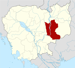
Chhloung District
| Chhloung ស្រុកឆ្លូង | |
|---|---|
| District (srok) | |
| Country |
|
| Province | Kratié |
| Communes | 8 |
| Villages | 37 |
| Population (1998)[1] | |
| • Total | 50,407 |
| Time zone | +7 |
| Geocode | 1001 |
Chhloung District (Khmer: ស្រុកឆ្លូង) is a district of Kratié Province, Cambodia.[2]
Communes and villages
| Khum (Commune) | Phum (Villages) |
|---|---|
| Chhloung | Chhney, Chrouy Thma Kraom, Chrouy Thma Leu, Kampong Srae, Kandal, Kaoh Kandaor |
| Damrei Phong | Boeng Kieb, Bos, Krouch, Prey Kou, Prahuot, Pralay Triek, Srae Sdach, Srae Triek |
| Han Chey | Hanchey Muoy, Hanchey Pir, Hanchey Bei, Hanchey Buon |
| Kampong Damrei | Prama, Roliek, Veal Kansaeng |
| Kanhchor | Chheu Teal Phluoh Leu, Chheu Teal Phluoh Kraom, Kanhchor, Preaek Chamlak |
| Khsach Andaet | Preaek Samraong Ti Muoy, Preaek Samraong Ti Pir, Preaek Ta Hub, Thmei Ti Muoy, Thmei Ti Pir |
| Pongro | Dang Kdaong, Pongro Muoy, Pongro Pir, Pongro Bei, Tnaot |
| Preaek Saman | Chheu Teal Phluoh, Chhak Kantoung, Dei Thmei, Lvea Thum, Preaek Saman |
References
- ↑ General Population Census of Cambodia, 1998: Village Gazetteer. National Institute of Statistics. February 2000.
- ↑ "Map 10. Administrative Areas in Kratie Province by District and Commune" (PDF). National Institute of Statistics, Ministry of Planning (Cambodia). 2013-12-31.
| ||||||||||||
This article is issued from Wikipedia - version of the Tuesday, November 03, 2015. The text is available under the Creative Commons Attribution/Share Alike but additional terms may apply for the media files.
