Chhapra
| Chhapra छपरा Chapra | |
|---|---|
| Metropolitan City | |
|
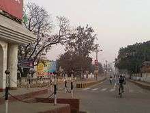
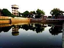
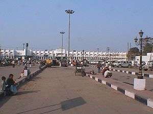
Anticlock wise from top left: Rajendra Sarovar, City Time Tower, Road Connecting Poice Station square and municipal square, Jai Prakash University, Rail Wheel Plant, Bela, Chhapra Railway Station. | |
 Chhapra Location in Bihar, India | |
| Coordinates: 25°47′05″N 84°43′39″E / 25.7848°N 84.7274°ECoordinates: 25°47′05″N 84°43′39″E / 25.7848°N 84.7274°E | |
| Country |
|
| State | Bihar |
| District | Saran |
| Area | |
| • Urban | 38.26 km2 (14.77 sq mi) |
| Elevation | 36 m (118 ft) |
| Population (2011) | |
| • Metropolitan City | 201,598 |
| • Urban | 249,556 |
| Demonym(s) | Chhaprahvi |
| Languages | |
| • Official | Bhojpuri, Hindi, Urdu, English |
| Time zone | IST (UTC+5:30) |
| PIN | 841301, 841302(Sandha) |
| Telephone code | +916152 |
| Lok Sabha constituency | Saran |
| Vidhan Sabha constituency | Chapra |
| Website |
saran |
Chhapra (also written Chapra) is a city and headquarters of the Saran district in the Indian state of Bihar. It is situated near the junction of the Ghaghara River and the Ganges River.
Chhapra grew in importance as a river-based market in the 18th century when the Dutch,[1][2] French, Portuguese, and English established saltpeter refineries in the area. It was recognized as a municipality in 1864. The city has major rail and road connections with the rest of India and a distance of few minutes from Uttar Pradesh by Train.
Geography


Chhapra is located at 25°47′05″N 84°43′39″E / 25.7848°N 84.7274°E.[3] It has an average elevation of 36 metres (118 ft).
The district of Saran is situated between 25°36' and 26°13' north latitude and 84°24' and 85°15' east longitude in the southern post of the Saran Division of North Bihar. The Ganges river provides the southern boundary of the district, beyond which lie the districts of Bhojpur and Patna. To the north of Saran lie the districts of Siwan and Gopalganj. The Gandak river forms the dividing line with the Vaishali and Muzaffarpur districts in the east. To the west of Saran lie the districts of Siwan and Balia in Uttar Pradesh. The Ghaghra river forms a natural boundary between Saran and Ballia.
The district is shaped like a triangle; its apex is the confluence of the boundary of the Gopalganj district and the Gandak – Ganges river. The district is made up entirely of plains, but several depressions and marshes create three broad natural divisions:
- The alluvial plains along the big rivers, which are subject to periodic inundation.
- The uplands away from the rivers, not subject to floods.
- The riverbed diara areas.
Out of twenty blocks in the districts, six (Sonepur, Dighwara, Revelganj, chapra, Manjhi and Dariyapur) regularly flood. Six others are partially affected by floods (Parsa, Marhoura, Amnaur, Jalalpur, and Ekma). The soil of the district is alluvial. No minerals of economic value are found in the district.
Climate
| Climate data for Chhapra | |||||||||||||
|---|---|---|---|---|---|---|---|---|---|---|---|---|---|
| Month | Jan | Feb | Mar | Apr | May | Jun | Jul | Aug | Sep | Oct | Nov | Dec | Year |
| Average high °C (°F) | 23.1 (73.6) |
25.8 (78.4) |
31.0 (87.8) |
35.1 (95.2) |
35.0 (95) |
34.9 (94.8) |
32.5 (90.5) |
32.8 (91) |
32.5 (90.5) |
31.6 (88.9) |
29.0 (84.2) |
24.8 (76.6) |
30.68 (87.21) |
| Average low °C (°F) | 9.2 (48.6) |
11.0 (51.8) |
15.1 (59.2) |
19.1 (66.4) |
21.2 (70.2) |
22.9 (73.2) |
23.8 (74.8) |
24.2 (75.6) |
23.8 (74.8) |
21.2 (70.2) |
15.8 (60.4) |
10.6 (51.1) |
18.16 (64.69) |
| Average precipitation mm (inches) | 13.0 (0.512) |
14.0 (0.551) |
9.0 (0.354) |
29.0 (1.142) |
76.0 (2.992) |
139.0 (5.472) |
353.0 (13.898) |
254.0 (10) |
193.0 (7.598) |
73.0 (2.874) |
6.0 (0.236) |
7.0 (0.276) |
1,166 (45.905) |
| Source: Accuweather[4] | |||||||||||||
Demographics
As per 2011 census, Chapra Urban Agglomeration had a population of 212,955.[5] Chapra Urban Agglomeration includes Chapra (Nagar Panchayat) and Sanrha (Census Town).[6] chapra Nagar Panchayat had a total population of 201,597, out of which 106,250 were males and 95,347 were females. It had a sex ratio of 897. The population below 5 years was 27,668. The literacy rate of Chhapra was 81.30 per cent as 2011.[7]
Education
- Jai Prakash University
- Loknayak Jai Prakash Institute Of Technology,Saran[8]
- Jagdam College
- Radiance Institute Of IT & Management (RIIM)
Gallery
-

A church in Chhapra.
-

Rajendra College, Chhapra
-

Loknayak Jai Prakash Institute Of Technology
-

Central View of Chhapra Junction
People from Chhapra
- Dr. Rajendra Prasad, freedom fighter and first president of India
- Jayaprakash Narayan, Political Leader From Sitabdiyara, Chhapra
- Bhikhari Thakur, poet and singer, "Shakespeare of Bhojpuri"
- Brajkishore Prasad, National Activitist
- Daroga Prasad Rai , 10th Chief Minister Of Bihar.
- Laloo Prasad Yadav ,Past Member of Parliament from Saran Constituency, Past Chief Minister of Bihar, Past Railway Minister Of India.
- Surur Hoda, Socialist leader and Order of British Empire (OBE) recipient.
- Chitragupta (composer), music director and father of composers Anand-Milind
- Anand-Milind, Music Composer and the sons of Chitragupta (composer).
- Mansur Hoda, Technologist, An alumni of Surrey University, England.
See also
- Dighwara
- Sonepur
- Pojhi Kapoor
- Sonauli
- Revelganj
- Panapur block
References
- ↑ Atlas of Mutual Heritage
- ↑ Atlas of Mutual Heritage
- ↑ Falling Rain Genomics, Inc - Chapra
- ↑ "Accuweather: Weather for Chhapra, India". Accuweather. 2011. Retrieved on November 22, 2011.
- ↑ "Urban Agglomerations/Cities having population 1 lakh and above" (PDF). Provisional Population Totals, Census of India 2011. Retrieved 2012-04-16.
- ↑ "Constituents of urban Agglomerations Having Population 1 Lakh & above" (PDF). Provisional Population Totals, Census of India 2011. Retrieved 2012-04-16.
- ↑ "Cities having population 1 lakh and above" (PDF). Provisional Population Totals, Census of India 2011. Retrieved 2012-04-16.
- ↑ "CM inaugurates new engineering college at Chhapra". The Times Of India. 26 December 2012. Retrieved 26 December 2012.
External links
| ||||||||||||||||||||||||||||||||||||||||||||||||||||||||||||||||
