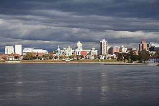
Downtown Harrisburg, Pennsylvania
| Downtown | |
|---|---|
| Neighborhood of Harrisburg | |
|
Downtown Harrisburg and the Susquehanna River | |
| Country |
|
| State | Pennsylvania |
| County | Dauphin County |
| City | Harrisburg |
| Area code(s) | Area code 717 |
Downtown Harrisburg, is the central core business and government center which surrounds the focal point of Market Square, and serves as the regional center for the greater metropolitan area of Harrisburg, Pennsylvania, USA.
Harrisburg's downtown Center City comprises the original 80-acre (320,000 m2) borough laid out in a grid pattern by John Harris in 1785. East-west streets are named and north-south streets are numbered. Market Street, running east-west, is the dividing point between north and south street designations. Sightseeing is probably best done on foot downtown and by car elsewhere.[1]
Harrisburg's Central Business District includes the Pennsylvania State Capitol Complex and other state government offices, the Dauphin County Courthouse and other county government offices, City of Harrisburg offices, and other, non-government related commercial retail and office development. Some residential development, both in apartment high-rises and in the upper floors of mixed commercial/residential use buildings, is also located in the downtown area.
Downtown is bordered in the northwest by the mixed commercial/residential use Capitol District, in the west by the Susquehanna River, in the southwest by the largely residential Shipoke neighborhood, in the south by Interstate 83, in the east by Amtrak and Norfolk Southern Railway lines, and in the north by Midtown Harrisburg, a mixed-use commercial and residential neighborhood. Forster Street is usually considered the boundary between Downtown and Midtown Harrisburg. City Island, located in the middle of the Susquehanna River directly west of downtown, is typically considered part of Downtown Harrisburg.
Demographics
As of the 2000 census[2] there were 1,999 people living in downtown. The racial makeup was 64.4% White, 27.9% African-American, 2.2% Asian and 4.5% were Hispanic or Latino of any race. The largest age group is those aged 25–34 at 19.1% of the population.
Education and Culture
Harrisburg's downtown has become a vibrant scene of restaurants, nightclubs, shops and museums over the past several years.
Most notably, the Harrisburg University of Science and Technology, founded in 2001, is located at the corner of Market and 4th streets. Temple University and Messiah College both have campuses downtown.
"SoMa" (South of Market) District
In 2007, the Harristown Development Corporation, a private authority formed to redevelop downtown Harrisburg, designated downtown Harrisburg bounded by Market to the north, 3rd to the west, Chestnut to the south, and 4th to the east as Harrisburg's "SoMa" or South of Market district. Harrisburg plans to add brick-accented walkways and SoMa banners on the light poles to indicate the district's location. The development corporation is trying to foster a desirable location for international business and arts.
- The Susquehanna art museum is located at the corner of 3rd and Market and features local and traveling national and international art exhibitions.
- The Whitaker Center for Science and the Arts on Market street hosts an IMAX theater, children's science museum with traveling exhibits, a gift shop and Starbucks coffee.
- Capital Area School for the Arts has a location on south 3rd street.
- Messiah College's Harrisburg Institute
- Harrisburg's International Place and International House for traveling students, which also serves as the only housing for Harrisburg University
SoMa also includes several restaurants, bars and two nightclubs, an African-American bookstore, record store, and other shops.
Retail
A small shopping mall, Strawberry Square, is the most notable commercial development in the downtown area. The Shops On Third is a collection of several upscale retail offerings along 3rd street just north of Market.
Most of downtown's service retail is located along the Market and 2nd street corridors.
Restaurant Row
2nd street from Market to Forster is sometimes referred to as Restaurant Row for its collection of eateries. Most of Harrisburg's nightlife also takes place on 2nd street, where several bars and dance clubs call home.
External links
See also
- Market Square in Harrisburg
- List of Harrisburg neighborhoods
References
- ↑ city-data.com
- ↑ "American FactFinder". United States Census Bureau. Retrieved 2008-01-31.
Coordinates: 40°15′35″N 76°52′54″W / 40.25969°N 76.88165°W
| ||||||||||||||
