Casanare Department
| Department of Casanare Departamento de Casanare | |||
|---|---|---|---|
| Department | |||
| |||
|
Motto: Trabajo y Libertad (Spanish: Work and Liberty) | |||
| Anthem: Himno de Casanare | |||
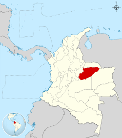
 Casanare shown in red | |||
| Coordinates: 5°21′0″N 72°24′36″W / 5.35000°N 72.41000°WCoordinates: 5°21′0″N 72°24′36″W / 5.35000°N 72.41000°W | |||
| Country |
| ||
| Region | Orinoquía Region | ||
| Established | July 4, 1991 | ||
| Capital | Yopal | ||
| Government | |||
| • Governor | Raúl Flórez (2008-) | ||
| Area | |||
| • Total | 44,640 km2 (17,240 sq mi) | ||
| Area rank | 10th | ||
| Population (2013)[1] | |||
| • Total | 344,027 | ||
| • Rank | 25th | ||
| • Density | 7.7/km2 (20/sq mi) | ||
| Time zone | UTC-05 | ||
| ISO 3166 code | CO-CAS | ||
| Municipalities | 19 | ||
| Website | www.casanare.gov.co | ||
Casanare (Spanish pronunciation: [kasaˈnaɾe]) is a department of Colombia. It is in the central eastern region of the country. Its capital is Yopal. It contains oil fields and an 800 km pipeline leading to the coastal port of Coveñas owned by BP.
Rivers and Dams
The Upia River (Río Upía) is in Casanere.[2]
Municipalities
- Aguazul
- Chameza
- Hato Corozal
- La Salina
- Maní
- Monterrey
- Nunchía
- Orocue
- Paz de Ariporo
- Pore
- Recetor
- Sabanalarga
- Sacama
- San Luis de Palenque
- Tamara
- Tauramena
- Trinidad
- Villanueva
- Yopal
Notes
- ↑ "DANE". Retrieved February 13, 2013.
- ↑ http://www.ingetec.com.co/brochures-ingles/BROCHURE-PRESAS-INGLES.pdf
External links
- (Spanish) Government of Casanare official website
| ||||||||
|
This article is issued from Wikipedia - version of the Sunday, May 17, 2015. The text is available under the Creative Commons Attribution/Share Alike but additional terms may apply for the media files.


