Casabó
| Casabó - Pajas Blancas | |
|---|---|
| Barrio | |
|
Main street in Pajas Blancas | |
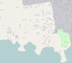
 Overall map of Casabó - Pajas Blancas | |
 Location of Casabó - Pajas Blancas in Montevideo | |
| Coordinates: 34°52′0″S 56°18′30″W / 34.86667°S 56.30833°WCoordinates: 34°52′0″S 56°18′30″W / 34.86667°S 56.30833°W | |
| Country |
|
| Department | Montevideo Department |
| City | Montevideo |
| Time zone | UTC -3 |
| Postal code | 12800 & 12700 |
| Dial plan | +598 2 (+7 digits) |
Casabó - Pajas Blancas is a composite barrio (neighbourhood or district) of Montevideo, Uruguay.
Location
The neighbourhood of Casabó is located in the southwestern part of Montevideo, between the districts of Santa Catalina to the west, Villa del Cerro to the east, Villa Esperanza to the north and the Río de la Plata to the south.
34°53′0″S 56°16′0″W / 34.88333°S 56.26667°W
Casabó is the western extension of the Villa del Cerro and it includes the Fortaleza del Cerro, the Parque Dr. Carlos Vaz Ferreira and the ruins of the cold storage factory Frigorífico Swift, the shut down Frigorífico Nacional, the Club de Golf del Cerro and the an area of the Navy. To the west of Casabó is the barrio of Santa Catalina, situated next to the beach and the public park of Punta Yeguas.
Places of worship
- Parish Church of St. Alberto Hurtado, Sierra Leona 144 (Roman Catholic)
- Parish Church of the Curé of Ars and St Helena, Av. Antártida Uruguaya 6100 (Roman Catholic)
Population
In 2004, Pajas Blancas had 1,976 inhabitants.[1] This number is not included in the population count of the city of Montevideo.
| Year | Population |
|---|---|
| 1963 | 925 |
| 1975 | 921 |
| 1985 | 1,257 |
| 1996 | 1,837 |
| 2004 | 1,976 |
Source: Instituto Nacional de Estadística de Uruguay[2]
Street maps
 Street map of Casabo & Santa Catalina |
 Street map of Pajas Blancas |
Photos
 Zabala Beach in Pajas Blancas |
 View of Cerro from Punta Yeguas |
References
- ↑ "2004 Census of Montevideo department" (XLS). INE. 2004. Retrieved 4 July 2011.
- ↑ "1963–1996 Statistics / P" (DOC). Instituto Nacional de Estadística de Uruguay. 2004. Retrieved 4 July 2011.
See also
| Wikimedia Commons has media related to Casabo, Pajas Blancas. |

