Cape Martyan Reserve
| Cape Martyan Reserve | |
|---|---|
| Мыс Мартьян | |
|
IUCN category Ia (strict nature reserve) | |
.svg.png) | |
| Location | Crimea, Russia/Ukraine[1] |
| Nearest city | Yalta |
| Coordinates | 44°30′25″N 34°15′03″E / 44.5068713°N 34.250871°ECoordinates: 44°30′25″N 34°15′03″E / 44.5068713°N 34.250871°E |
| Area | 240 ha (590 acres) |
| Established | 1973 |
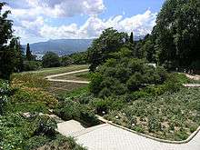
Cape Martyan Reserve (Ukrainian: Мис Мартьян) is an IUCN Category – Ia (Strict nature reserve). It situated in Crimea, near the city of Yalta. It is also situated near the Nikitsky Botanical Gardens, which is where most of the scientific research on plants is conducted in Ukraine. The reserve was created to save naturally valuable systems of Cape Martyan in natural state, to protect and to preserve rare species of flora and fauna, and to conduct scientific research.
History
This reserve was established in 1973 by the decree of The Council of Ministers of the Ukrainian Soviet Socialist Republic of February 20, 1973 № 84 on lands Nikitsky botanical garden. The area of the reserve is 240 hectares (590 acres), including 120 hectares (300 acres) of land and 120 hectares (300 acres) in the adjoining Black Sea.
Geography
The area of allocation reserve is a region of complex and lengthy geological processes related with the deposition of sedimentary rocks (mostly of limestone) and with the raising of the crust. As a result, fragments of limestone from Nikita`s chain broke away and dropped into the sea and formed Cape Martyan. In orography this is a trail that is dissected by gullies, that stretch from Nikita's chain and dropped into the sea in some places (up to 100–200 m (330–660 ft)). The reserve covers the lower part of trail to a height of 250 m (820 ft) above sea level.
Climate
The climate in reserve is warm and dry, because the north side is protected from cold winds by The Main ridge with the height 1,200–1,400 m (3,900–4,600 ft) above sea level. Summers are hot and dry, and winters are mild and wet. The average annual temperature is 13.3–13.9 °C (55.9–57.0 °F), average July temperature -- 25 °C (77 °F), February -- 4 °C (39 °F), that characterized by rather low amplitude of oscillations. The average annual rainfall is 560 mm (22 in).
Biota
Here were saved typical natural landscapes and rich genetic fund of flora and fauna of Mediterranean type. This is due to the fact that the reserve is located on the northern boundary of Mediterranean floristic region. The aquatoria of the reserve is one of a few areas that were saved on the southern coast of Crimea in natural state, with a typical demersal flora.
Flora
The vegetation of the reserve is typical for Crimea Mediterranean community. Generally vegetation are composed of forests, most of which are presented by Downy Oak (Quercus pubescens) and, less - Greek Juniper (Juniperus excelsa) and very small - Pinus nigra. Warm climate and sufficient rainfall contribute to the spread in their unique in Crimea evergreen leaf tree - Greek Strawberry Tree (Arbutus andrachne) and shrubberies: Cistus tauricus, Ruscus aculeatus, Hedera taurica.
References
- ↑ This place is located on the Crimean Peninsula, most of which is the subject of a territorial dispute between Russia and Ukraine. According to the political division of Russia, there are federal subjects of the Russian Federation (the Republic of Crimea and the federal city of Sevastopol) located on the peninsula. According to the administrative-territorial division of Ukraine, there are the Ukrainian divisions (the Autonomous Republic of Crimea and the city with special status of Sevastopol) located on the peninsula.
External links
- Relic Vegetation of Cape Martyan Reserve
- Информация на сайта Украина Инкогнита
- Заповедники Крыма
- Государственный заповедник «Мыс Мартьян»
- Заповедник «Мыс Мартьян», Ялта
