Camden, South Carolina
| Camden, South Carolina | |
|---|---|
|
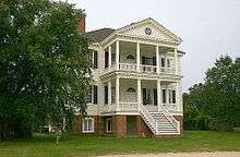
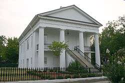
Original Kershaw County courthouse in Camden | |
| Nickname(s): Steeplechase Capital of the World | |
|
| |
| Coordinates: 34°15′33″N 80°36′33″W / 34.25917°N 80.60917°WCoordinates: 34°15′33″N 80°36′33″W / 34.25917°N 80.60917°W | |
| Country | United States |
| State | South Carolina |
| County | Kershaw |
| Founded | March 22, 1786 |
| Government | |
| • Mayor | Tony P. Scully |
| Area | |
| • Total | 10.68 sq mi (27.7 km2) |
| • Land | 10.07 sq mi (26.1 km2) |
| • Water | 0.61 sq mi (0.3 km2) 5.71% |
| Elevation | 187 ft (57 m) |
| Population (2010) | |
| • Total | 6,838 |
| • Density | 724.8/sq mi (280.8/km2) |
| Time zone | Eastern (UTC-5) |
| • Summer (DST) | Eastern (UTC-4) |
| ZIP codes | 29020, 29021 |
| Area code(s) | 803 |
| FIPS code | 45-10855[1] |
| GNIS feature ID | 1247113[2] |
| Website |
www |
Camden is a city in, and the county seat of, Kershaw County, South Carolina, United States.[3] The population was 6,838 in the 2010 census.[4] It is part of the Columbia, South Carolina, Metropolitan Statistical Area.
Geography
According to the United States Census Bureau, Camden has a total area of 10.68 square miles (27.7 km2), of which 10.07 square miles (26.1 km2) is land and 0.61 square miles (1.6 km2) (5.71%) is water.
History
Camden is the oldest inland city and fourth oldest city in South Carolina. It is near the center of the Cofitachequi chiefdom that existed in the 1500s.[5] In 1730, Camden became part of a township plan ordered by King George II. Kershaw County’s official web site states, “Originally laid out in 1732 as the town of Fredericksburg in the Wateree River swamp (south of the present town) when King George II ordered eleven inland townships established along South Carolina's rivers, few of the area settlers chose to take lots surveyed in the town, choosing the higher ground to the north. The township soon disappeared.” In 1758, Joseph Kershaw, from Yorkshire, England came into the township, established a store and renamed the town Pine Tree Hill. Camden became the main inland trade center in the colony. Kershaw suggested that the town be renamed Camden, in honor of Lord Camden, the champion of colonial rights.
May 1780 brought the American Revolution to Charleston, South Carolina, when it fell under the Crown's control. Lord Charles Cornwallis and 2,500 of his Loyalist and British troops marched to Camden and established there the main British supply post for the Southern campaign. The Battle of Camden, the worst American defeat of the Revolution, was fought on August 16, 1780 near Camden, and on April 25, 1781 the Battle of Hobkirk Hill was fought between about 1,400 troops led by General Nathanael Greene and 950 Loyalists and British soldiers led by Lord Francis Rawdon. The latter battle was a costly win for the British, and forced them to leave Camden and retreat to the coast. After the Revolution, Camden's prominence and wealth grew as a major interior trading town with direct ties to Charleston and the world. Regional products, augmented with goods from the interior of North Carolina and far lands to the west were transported from Camden to Charleston on flat-bottom riverboats that plied the adjacent Wateree river before the railroad arrived in 1842.
Camden, although not involved directly with the Civil War, did send six generals who contributed significantly. Richard Rowland Kirkland - 'The Angel of Marye's Heights' - is interred in the Old Quaker Cemetery. At the end of the war, components of Sherman's army burned Confederate and nearby properties including a full block of downtown buildings. The last Federal officer killed in the Civil War died in a skirmish near Camden.
Starting in the mid-1880s the Camden area became an increasingly popular destination for wealthy northern families to spend the winter. Eventually three resort hotels provided state of the art winter tourism activities well into the 1930s and beyond. The town became associated with many equestrian activities, and is now the home of the third oldest active polo field in America. In the winter, more than 1,500 thoroughbreds call the area home. According to Kershaw County’s web site, “Horse related activities became very popular. That interest in equine activities has continued and today the horse industry is a major part of the county economy. For that reason, the county is known as the ‘Steeplechase Capital of the World’.”
Because of its long history and many years of wealthy winter visitors and deep-pocket northern owners, Camden has an enviable inventory of antebellum homes and charm that remains unique among towns of its size in South Carolina and elsewhere.
The Adamson Mounds Site, Belmont Neck Site -38KE06, Bethesda Presbyterian Church, Boykin Mill Complex, Camden Battlefield, Zachariah Cantey House, Carter Hill, City of Camden Historic District, Cool Springs, Thomas English House, Historic Camden Revolutionary War Restoration, Kendall Mill Historic District, McDowell Site, Mulberry Plantation (James and Mary Boykin Chesnut House), and Seaboard Air Line Railway Depot are listed on the National Register of Historic Places.[6]
Demographics
| Historical population | |||
|---|---|---|---|
| Census | Pop. | %± | |
| 1850 | 1,133 | — | |
| 1860 | 1,621 | 43.1% | |
| 1870 | 1,007 | −37.9% | |
| 1880 | 1,780 | 76.8% | |
| 1890 | 3,533 | 98.5% | |
| 1900 | 2,441 | −30.9% | |
| 1910 | 3,569 | 46.2% | |
| 1920 | 3,930 | 10.1% | |
| 1930 | 5,183 | 31.9% | |
| 1940 | 5,747 | 10.9% | |
| 1950 | 6,986 | 21.6% | |
| 1960 | 6,842 | −2.1% | |
| 1970 | 8,532 | 24.7% | |
| 1980 | 7,462 | −12.5% | |
| 1990 | 6,696 | −10.3% | |
| 2000 | 6,682 | −0.2% | |
| 2010 | 6,838 | 2.3% | |
| Est. 2014 | 7,030 | [7] | 2.8% |
| U.S. Decennial Census | |||
As of the census[1] of 2010, there were 6,838 people residing in the city limits, in 2,967 households and 1,800 families. The population density was 692.2 people per square mile (267.4/km²). There were 3,544 housing units at an average density of 331.8 per square mile (127.9/km²). The racial makeup of the city was 62.2% White, 35.1% African American, 0.20% Native American, 0.7% Asian, 0% Pacific Islander, 2.7% from other races, and 1.1% from two or more races. Hispanic or Latino of any race were 2.4% of the population.
There were 2,967 households out of which 27.7% had children under the age of 18 living with them, 41.1% were married couples living together, 16.5% had a female householder with no husband present, and 36.3% were non-families. 35.6% of all households were made up of individuals and 18.9% had someone living alone who was 65 years of age or older. The average household size was 2.26 and the average family size was 2.94.
In the city the population was spread out with 21.9% under the age of 18, 20.1% from 18 to 39, 34.5% from 40 to 64, 17.3% from 65 to 84, and 4.3% who were 85 years of age or older. The median age was 45.3 years. 45.0% of the population was male and 55.0% of the population was female.

The median income for a household in the city was $48,313, and the median income for a family was $62,140. Males had a median income of $42,597 versus $32,524 for females. The per capita income for the city was $26,385. About 13.7% of families and 15.4% of the population were below the poverty line, including 19.3% of those under age 18 and 13.2% of those age 65 or over.
The Carolina Cup
The Carolina Cup is an annual event held on either the final Saturday in March or the first Saturday of April. The first race was held March 22, 1930 and has been held every year since, with the exception of 1943 and 1945, during World War II. The races have become a South Carolina tradition, and normally draw a crowd of over 70,000 spectators. The "Cup" has become a premier social sporting event.
Among major steeplechase horse races, it is unique in that South Carolina state law prohibits gambling on horse racing.
Colonial Cup
Springdale Race Course is also home, since 1970, to the Marion duPont Scott Colonial Cup held on the third Sunday in November annually. In addition to James Madison's Montpelier in Orange County, Virginia, Marion duPont Scott owned Holly Hedge in Camden from 1944 until her death in 1983.
Historic landmarks
Education
- Camden High School
- Applied Technology Education Campus (ATEC)
- Camden Middle School
- Camden Elementary School of the Creative Arts
- Pine Tree Hill Elementary School
- Jackson Elementary School
- Camden Military Academy
- The Buckley School of Public Speaking
Transportation
- Seaboard Air Line Railway Depot
- Woodward Field, also known as the Kershaw County Airport
Notable people
- Patricia Buckley Bozell - author and publisher, reared in Camden
- Mary Chesnut - author and Civil War diarist.
- Kathleen Parker, current resident, winner of the 2010 Pulitzer Prize for Commentary
- Samuel E. Wright, American actor and Broadway performer
- Larry Doby - first African American to play in the American League
- Bobby Engram - NFL player
- Vonnie Holliday - NFL player
- Charles Bennett - NFL player
- Richie Williams - CFL player
- Bernard Baruch - American financier and American presidential adviser
- Vincent Sheheen - state Senator and 2010 Democratic nominee for Governor
- Michael Kohn - Major League Baseball player, pitcher for Los Angeles Angels
- John C. West - Governor of South Carolina (1971-1975)
- Lois Rhame West - First Lady of South Carolina (1971-1975), first woman to chair the Muscular Dystrophy Association.[8]
- Hastings Wyman - political consultant, journalist, and author; resided part of his childhood in Camden
- West McMehan - Film Actor and Model representing SC and NY Markets [9]
- Lorenzo James - Alabama politician
References
- 1 2 "American FactFinder". United States Census Bureau. Retrieved 2008-01-31.
- ↑ "US Board on Geographic Names". United States Geological Survey. 2007-10-25. Retrieved 2008-01-31.
- ↑ "Find a County". National Association of Counties. Retrieved 2011-06-07.
- ↑ http://quickfacts.census.gov/qfd/states/45/4510855.html
- ↑ Charles Hudson (September 1998). Knights of Spain, Warriors of the Sun: Hernando de Soto and the South's Ancient Chiefdoms. University of Georgia Press. pp. 234–238. ISBN 978-0-8203-2062-5. Retrieved February 16, 2012.
- ↑ Staff (2010-07-09). "National Register Information System". National Register of Historic Places. National Park Service.
- ↑ "Annual Estimates of the Resident Population for Incorporated Places: April 1, 2010 to July 1, 2014". Retrieved June 4, 2015.
- ↑ O'Mara, Dan (2014-05-06). "Winthrop alum Lois Rhame West, former SC first lady and 'bright light,' dies". The Herald (Rock Hill). Retrieved 2014-07-13.
- ↑ "Southeast Talent Search- Success Stories". www.setalentsearch.com. Retrieved 2015-12-27.
Further reading
- Stokes, Karen D., ed. “Sherman’s Army Comes to Camden: The Civil War Narrative of Sarah Dehon Trapier,” South Carolina Historical Magazine, 109 (April 2008), 95–120.
- Joan & L. Glen Inabinet "A History of Kershaw County, South Carolina" The University of South Carolina Press, 718pg. (2011) 90, 237, 271, 328, 398, 427,431, 433, 538, 558-59
External links
| Wikimedia Commons has media related to Camden, South Carolina. |
| |||||||||||||||||||||||||

