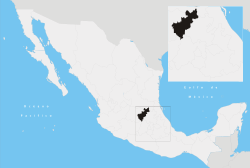
Cadereyta de Montes
| Location | 20°41′28″N 99°49′08″W / 20.691°N 99.819°W | |
| Municipal president | Rodrigo Mejia Hernandez 2012-2015 (PRI) | |
| Surface | 1,131 square kilometres (437 sq mi) | |
| Population (2005) | 57,204 | |
| HDI (2000) | 0.7074 | |
| Time zone (UTC) | -6 UTC CST | |
| GDP (per capita) (2000) | US$3,112 | |
| ||
Cadereyta de Montes (Spanish ![]() ) is a city and municipality in Querétaro, Mexico. The municipality is the second most extensive in the state.
) is a city and municipality in Querétaro, Mexico. The municipality is the second most extensive in the state.
The city was founded in 1640, and received its current name in two stages: first in 1642 in honor of Viceroy Don Lope Díez de Armendáriz, marqués de Cadereyta, and then in 1904 after the lawyer Ezequiel Montes. From its conception during the Spanish rule of Mexico, the city was intended to become quite important. It received the status of Alcaldía mayor in 1689, thus becoming the dominant city in this part of the state. It was a post from which the main trade routes were defended from attacks by the indigenous people of the Sierra Gorda.
A famous greenhouse called Finca Schmoll is in the city, preserving a large collection of desert plants open to the public.
The population of the municipality grew from 51,688 in 2000 to 57,204 in 2005.
External links
- Cadereyta de Montes (Spanish)
- Cadereyta de Montes (Spanish)
- Encyclopedia of the municipalities of Mexico (Spanish)
| |||||||||||||
Coordinates: 20°42′N 99°49′W / 20.700°N 99.817°W
