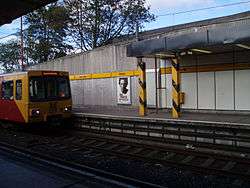
Byker Metro station
| Byker | |
|---|---|
| Tyne and Wear Metro | |
|
| |
 | |
| Location | |
| Place | Byker |
| Local authority | Newcastle |
| Fare zone information | |
| Network One zone | 1 |
| Metro zone | A |
| Original (1979) zone | 27 |
| Station code | BYK |
| History | |
| Opened | 1982-11-14 |
| List of stations | |
Byker Metro station is located in Byker, an area in the east end of Newcastle upon Tyne.
The station is on the Yellow line of the Tyne and Wear Metro system, and opened in 1982. In 2008-9, the station was used by around 430,000 passengers.[1]
Heading west from Byker station, the route crosses the dramatic 800 m Byker Viaduct constructed by Arup specifically for the Metro.
Since 2005, Byker station has been used to display a series of temporary artworks through the Next Stop Byker initiative, a partnership between Metro operator Nexus and Newcastle City Council. The works are displayed on an 11 metre by 2.5 metre wall in the ticket concourse.[2]
Prior to the Metro being built, there was a British Rail railway station called Byker north of Shields Road on the Riverside Branch but it closed to passengers in 1954.
Ticketing anomalies
Different zonal fare systems are used for Metro single tickets and inter-modal Transfare tickets, which means that for a number of journeys a Transfare may actually be cheaper than a standard Metro-only ticket.
| Station | Network Zone | Metro Zone |
|---|---|---|
| Cullercoats | 29 | C |
| North Shields | 29 | C |
| Tynemouth | 29 | C |
| Wallsend | 27 | B |
References
External links
| Wikimedia Commons has media related to Byker Metro station. |
- Train times and station information for Byker Metro station from Nexus
Coordinates: 54°58′34″N 1°34′47″W / 54.9761°N 1.5798°W
| Preceding station | Tyne and Wear Metro | Following station | ||
|---|---|---|---|---|
towards St James | Yellow line | towards South Shields |