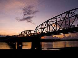
Buntun Bridge
Coordinates: 17°36′49″N 121°41′29″E / 17.61361°N 121.69139°E
| Buntun Bridge | |
|---|---|
|
Buntun Bridge Aerial View | |
| Carries | 2 lanes of vehicular traffic; pedestrian sidewalks |
| Crosses | Cagayan River |
| Locale |
Tuguegarao, Cagayan (North) Solana, Cagayan (South) |
| Official name | Buntun Bridge |
| Maintained by | Department of Public Works and Highways |
| Characteristics | |
| Material | Concrete, Asphalt |
| Total length | 1369 m |
| Height | 37 m (121 ft) |
| History | |
| Constructed by | Philippine National Construction Corporation |
| Construction end | 1947 |
| Opened | 1947-present |
| Statistics | |
| Toll | No |
Buntun Bridge is a river bridge from Tuguegarao City proper. It is the second longest bridge in the country and offers an unobstructed view of the Cagayan River.[1] This 1.098 km-long bridge links Tuguegarao City to the 2nd and 3rd District Municipalities of Cagayan Province & the Apayao Province.[2] Buntun Bridge is considered as the longest river bridge in the Philippinnes. It stretches from Tuguegarao City to Solana, Cagayan and spans the Cagayan River, the largest river basin in the Philippines.[3]
See also
References
This article is issued from Wikipedia - version of the Friday, December 04, 2015. The text is available under the Creative Commons Attribution/Share Alike but additional terms may apply for the media files.
