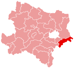
Bruck an der Leitha District
| Bezirk Bruck an der Leitha | |
|---|---|
| District | |
 | |
| Country | Austria |
| State | Lower Austria |
| Number of municipalities | 20 |
| Area | |
| • Total | 495.0 km2 (191.1 sq mi) |
| Population (2001) | |
| • Total | 40,006 |
| • Density | 81/km2 (210/sq mi) |
| Time zone | CET (UTC+1) |
| • Summer (DST) | CEST (UTC+2) |
| NUTS code | AT122 |
Bezirk Bruck an der Leitha is a district of the state of Lower Austria in Austria.
Municipalities

Gallbrunn, Austria

Göttlesbrunn, Austria
Towns (German: Städte) are indicated in boldface; market towns (Marktgemeinden) in italics; suburbs, hamlets and other subdivisions of a municipality are indicated in small characters.
- Au am Leithaberge
- Bad Deutsch-Altenburg
- Berg
- Bruck an der Leitha
- Bruck an der Leitha, Wilfleinsdorf, Schloss Prugg
- Enzersdorf an der Fischa
- Enzersdorf an der Fischa, Margarethen am Moos
- Göttlesbrunn-Arbesthal
- Arbesthal, Göttlesbrunn
- Götzendorf an der Leitha
- Götzendorf an der Leitha, Pischelsdorf
- Hainburg an der Donau
- Haslau-Maria Ellend
- Haslau an der Donau, Maria Ellend
- Hof am Leithaberge
- Höflein
- Hundsheim
- Mannersdorf am Leithagebirge
- Mannersdorf am Leithagebirge, Wasenbruck
- Petronell-Carnuntum
- Prellenkirchen
- Deutsch-Haslau, Prellenkirchen, Schönabrunn
- Rohrau
- Gerhaus, Hollern, Pachfurth, Rohrau
- Scharndorf
- Regelsbrunn, Scharndorf, Wildungsmauer
- Sommerein
- Trautmannsdorf an der Leitha
- Gallbrunn, Sarasdorf, Stixneusiedl, Trautmannsdorf an der Leitha
- Wolfsthal
See also
- Leithagebirge
- Leitha (River)
- Moos (River)
- Neusiedl am See District
- Eisenstadt-Umgebung District
| ||||||||||||
Coordinates: 48°04′01″N 16°46′44″E / 48.067°N 16.779°E
This article is issued from Wikipedia - version of the Friday, February 22, 2013. The text is available under the Creative Commons Attribution/Share Alike but additional terms may apply for the media files.
