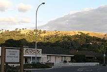
Brown Hill, Mitcham


Brown Hill, South Australia, 34°59′S 138°38′E / 34.983°S 138.633°E, is a bare hill on the western edge of the Mount Lofty Ranges, seven km southeast of the centre of Adelaide, near the suburb of Mitcham. Brown Hill rises to 312 metres (1,024 ft)above sea level.
Brown Hill, along with Mount Lofty, Green Hill, Flagstaff Hill and Black Hill, was used by Colonel William Light as a trig station for the 1837 survey of what is now the Adelaide city centre. Captain Collet Barker probably named Brown Hill when seen from Gulf St Vincent or in 1836 when in the Mitcham area.
The hill was covered with grasses at the time of European settlement, probably due the burning practices of the Kaurna people. Grazing of livestock since European settlement has resulted in loss of much of the native vegetation and the ingress of many weed species. In 1998, a 30 hectares (74 acres) site, including Brown Hill, was acquired by the City of Mitcham and established as Brownhill Reserve. A management plan was established to attempt regenerate the native flora and to control exotic weeds.
External links
- Brown Hill, Mitcham is at coordinates 34°59′06″S 138°38′13″E / 34.985°S 138.637°ECoordinates: 34°59′06″S 138°38′13″E / 34.985°S 138.637°E