Brixey, Missouri
| Brixey, Missouri | |
|---|---|
| Community | |
|
Old store building at Brixey | |
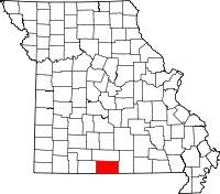
 Brixey, Missouri Location of Brixey, Missouri | |
| Coordinates: 36°45′3″N 92°24′16″W / 36.75083°N 92.40444°WCoordinates: 36°45′3″N 92°24′16″W / 36.75083°N 92.40444°W[1] | |
| Country | U. S. A. |
| State | Missouri |
| County | Ozark County |
| Elevation[1] | 300 m (1,000 ft) |
| Time zone | CST (UTC-6) |
| • Summer (DST) | CDT (UTC-5) |
| Zip Code | 65618 |
Brixey is a small unincorporated community in northern Ozark County, Missouri, USA. It is 1.6 miles (2.6 km) south of Route 95 on Route N or about 10 miles (16 km) north of Gainesville.[1][2]
Post office sign on the porch of the Brixey store
The Brixey post office was established in 1917. The zip code is 65618. The village was named for Brixey Creek which lies just northwest of the site.[3][4]
References
- 1 2 3 Rockbridge, Missouri, 7.5 Minute Topographic Quadrangle, USGS, 1973
- ↑ Ava, Missouri, 30x60 Minute Topographic Quadrangle, USGS, 1985
- ↑ Ozark County Place Names, 1928-1945
- ↑ US Zip Codes
| |||||||||||||||||||||||||||||
This article is issued from Wikipedia - version of the Sunday, July 27, 2014. The text is available under the Creative Commons Attribution/Share Alike but additional terms may apply for the media files.
