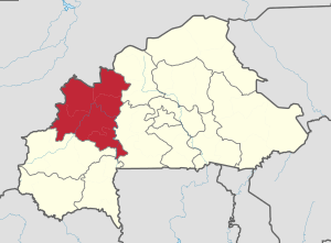
Boucle du Mouhoun Region
| Boucle du Mouhoun | |
|---|---|
| Region | |
|
Trucks loaded with cotton in Dédougou | |
 Location in Burkina Faso | |
| Coordinates: 12°30′N 3°30′W / 12.500°N 3.500°WCoordinates: 12°30′N 3°30′W / 12.500°N 3.500°W | |
| Country |
|
| Capital | Dédougou |
| Area | |
| • Total | 34,333 km2 (13,256 sq mi) |
| Population (2006) | |
| • Total | 1,434,847 |
| Time zone | GMT 0 (UTC+0) |
Boucle du Mouhoun is one of Burkina Faso's 13 administrative regions. It was created on 2 July 2001 and had a population of 1,434,847 in 2006. It is the 2nd most populous region in Burkina Faso after Centre Region, and contains 10.5% of all Burkinabé.[1] The region's capital is Dédougou. Six provinces make up the Boucle du Mouhoun region – Balé, Banwa, Kossi, Mouhoun, Nayala, and Sourou.
| Province | Capital | Population (Census 2006)[1] |
|---|---|---|
| Balé Province | Boromo | 213,897 |
| Banwa Province | Solenzo | 267,934 |
| Kossi Province | Nouna | 272,223 |
| Mouhoun Province | Dédougou | 298,008 |
| Nayala Province | Toma | 162,869 |
| Sourou Province | Tougan | 219,826 |
Languages
The main languages spoken in Boucle du Mouhoun as of 2006 were Moore, Bwamu, and Samo (or San).[2] (French is the official language throughout the country.)
References
- 1 2 National 2006 census preliminary results
- ↑ BOUGMA M., 2014. Dynamique des différentes langues en présence au Burkina Faso : les changements démo-linguistiques opérés au sein de la population burkinabè, 2014, Actes du XVIIe colloque international de l’AIDELF sur Démographie et politiques sociales, Ouagadougou, novembre 2012, 15 p.
This article is issued from Wikipedia - version of the Tuesday, July 14, 2015. The text is available under the Creative Commons Attribution/Share Alike but additional terms may apply for the media files.