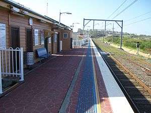
Bombo railway station
Bombo | |
|---|---|
|
NSW TrainLink intercity train station ← Minnamurra · Kiama → | |
 | |
| Location |
Princes Highway, Bombo New South Wales Australia |
| Coordinates | 34°39′30″S 150°51′14″E / 34.6584°S 150.8539°ECoordinates: 34°39′30″S 150°51′14″E / 34.6584°S 150.8539°E |
| Owned by | RailCorp |
| Line(s) | South Coast |
| Distance | 117.551 km from Central[1] |
| Platforms | 1, 196 metres[1] |
| Tracks | 3[1] |
| Train operators | NSW TrainLink |
| Bus operators | Premier Illawarra |
| Construction | |
| Structure type | At-grade |
| Parking | 8 spaces |
| Disabled access | Easy Access |
| Other information | |
| Fare zone | MyMulti3 |
| Website | Sydney Trains |
| History | |
| Opened | 9 November 1887[2] |
| Electrified | 17 November 2001 |
| Previous names |
North Kiama Kiama[2] |
| Traffic | |
| Passengers (2014) | 3,374[3] |
| Rank | 273rd of 307[4] |
Bombo is a single-platform intercity train station located in Bombo, New South Wales, Australia, on the South Coast railway line. The station serves NSW TrainLink trains travelling south to Kiama and north to Wollongong and Sydney.[5] Premier Illawarra services to Kiama and Shellharbour stop near the station. Bombo Station is listed on the state heritage register[6] and is reputedly the closest railway station in Australia to the sea.
Bombo Station opened as the temporary South Coast Line terminus in late 1887 under the name "North Kiama". The town of Kiama, situated among fingers of hard basaltic rock running down from Saddleback Mountain to the sea, presented something of a barrier to the railway's progress further south. Over the course of the next six years, engineers and workers from the firm of W. Monie & J. Angus worked to excavate the five tunnels required to bring the line through Kiama and onto the coastal plain beyond. North Kiama Station lost its terminal status in 1893 and declined in importance, losing its locomotive turntable to Kiama four years later.[6]
Though it no longer served the town proper, the station and yard remained important to the NSW Government Railways' basalt quarry at nearby Bombo Point, where mining had started in 1880. The station was renamed Bombo in 1907; a signal box was built in 1925 to assist in handling the trains laden with railway ballast and road aggregate.[6] The station yard retains a 523-metre passing loop and 159-metre down siding.[1]
Recent developments
The line from Dapto to Kiama was electrified on 17 November 2001, allowing electric multiple unit trains to run between Sydney and Bombo; the signal box was decommissioned around the same time. In 2009, the station became unattended following a network-wide review of low-patronage stations.[7] In 2014, electronic ticketing in the form of the Opal smart card became available at the station.[8]
Being sandwiched between Bombo Beach on one side and the six-lane Princes Highway on the other, and with only the quarries and a cemetery opposite, the station has a limited walking catchment and very low patronage (3,374 passenger movements in 2014). Critics have suggested that trains no longer stop at Bombo, arguing for a new station to the north in the centre of Kiama Downs. This proposal has not progressed, however.[9]
References
- 1 2 3 4 Asset Standards Authority (30 April 2015). "Train Operating Conditions (TOC) Manual – Track Diagrams (version 3.0)" (PDF).
- 1 2 Bozier, Rolfe. "NSWrail.net: Bombo Station".
- ↑ Bureau of Transport Statistics (March 2015). "Summary of train journeys (official patronage figures)".
- ↑ Bureau of Transport Statistics (November 2012). Compendium of Sydney Rail Travel Statistics, 8th Edition.
- ↑ Sydney Trains (October 2014). "South Coast Line – Bomaderry or Port Kembla to Central and Bondi Junction".
- 1 2 3 Office of Environment & Heritage (5 July 2009). "Bombo Railway Station Group".
- ↑ Needham, Kirsty (20 August 2009). "RailCorp left 22 positions unfilled". The Sydney Morning Herald.
- ↑ Opal card available on all Sydney trains by next Friday Sydney Morning Herald 20 March 2014
- ↑ Mackie, Graham (2 October 2013). "A station for Kiama Downs?". Kiama Independent.
External links
 Media related to Bombo railway station at Wikimedia Commons
- Bombo station details Sydney Trains
| ||||||||||||||||||||||||||||||||||||||