Bockelnhagen
| Bockelnhagen | ||
|---|---|---|
| Ortsteil of Sonnenstein | ||
| ||
 Bockelnhagen | ||
| Coordinates: 51°33′50″N 10°25′18″E / 51.56389°N 10.42167°ECoordinates: 51°33′50″N 10°25′18″E / 51.56389°N 10.42167°E | ||
| Country | Germany | |
| State | Thuringia | |
| District | Eichsfeld | |
| Municipality | Sonnenstein | |
| Area | ||
| • Total | 18.65 km2 (7.20 sq mi) | |
| Population (2010-12-31) | ||
| • Total | 410 | |
| • Density | 22/km2 (57/sq mi) | |
| Time zone | CET/CEST (UTC+1/+2) | |
| Postal codes | 37345 | |
| Dialling codes | 036072 | |
| Vehicle registration | EIC | |
| Website | www.bockelnhagen.de | |

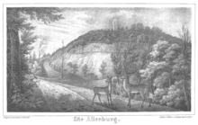
The Allerburg, a ruined castle at Bockelnhagen; by Carl Duval, c. 1840
Bockelnhagen is a village and a former municipality in the district of Eichsfeld in Thuringia, Germany. Since 1 December 2011, it is part of the municipality Sonnenstein. The community has two constituent parts, Bockelnhagen and Weilrode. Bockelnhagen is one of the few villages in the Eichsfeld district which were not part of the historical Eichsfeld.
History
The first written mention of Bockelnhagen dates to 1143. From 1816 on, after the Congress of Vienna, it belonged to the Erfurt district of the Prussian Province of Saxony.
References
|
This article is issued from Wikipedia - version of the Sunday, June 21, 2015. The text is available under the Creative Commons Attribution/Share Alike but additional terms may apply for the media files.
