Blumenau
| Blumenau | |||
|---|---|---|---|
|
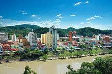
Itajaí-Açu river seen from the surroundings of Garcia's stream mouth; city centre at left | |||
| |||
| Nickname(s): Cidade Jardim ("Garden City") and Alemanha Tropical ("Tropical Germany") | |||
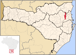
 Location in the state of Santa Catarina and Brazil | |||
| Coordinates: 26°55′08″S 49°03′57″W / 26.91889°S 49.06583°W | |||
| Country | Brazil | ||
| Region | South | ||
| State | Santa Catarina | ||
| Founded | September 2, 1850 | ||
| Government | |||
| • Mayor | Napoleão Bernardes (2013-2017) | ||
| Area | |||
| • Total | 519.837 km2 (200.710 sq mi) | ||
| Elevation | 21 m (69 ft) | ||
| Population (2010 est)[1] | |||
| • Total | 309,214 | ||
| • Density | 594.83/km2 (1,540.6/sq mi) | ||
| Time zone | GMT-3 | ||
| Postal code | 89000-000 | ||
| Area code(s) | +55 47 | ||
| Website | http://www.blumenau.sc.gov.br | ||
Blumenau is a city in Vale do Itajaí, state of Santa Catarina, in southern Brazil. It is 130 km away from the state capital, Florianópolis.
History
The city was founded on September 2, 1850, by Dr. Hermann Bruno Otto Blumenau along with seventeen German immigrants. Later arrivals include biologist and early proponent of Darwinian Evolution, Fritz Müller.
Demographics
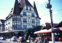
As of 2006, Blumenau had an estimated population of 302,000 people, with an area of 519 km². The main ethnic origin of the city inhabitants are German and Italian.[2] The city displays many historical and cultural reminders of their heritage, such as houses and other buildings built in a traditional German style, statues, and memorials.
Blumenau, compared to other Brazilian cities, has a very high standard of living, with a Human Development Index of 0.855 as of 2000.[3]
Ethnic composition
| Race/Skin color | Percentage | Number |
| Whites | 94.55% | 247,527 |
| Pardos (Mixed-race) | 3.50% | 9,171 |
| Blacks | 1.16% | 3,042 |
| Amerindians | 0.13% | 340 |
| Asian | 0.10% | 252 |
Religion
| Religion | Percentage | Number |
| Catholics | 73.90% | 193,474 |
| Protestants | 22.13% | 57,935 |
| No religion | 1.22% | 3,200 |
| Kardecists | 0.72% | 1,894 |
Geography

The city is located in a valley bisected by the Itajaí-Açu River, surrounded by hills with forests. The lower areas, including towers and tall buildings in the city center, constantly suffer from the threat of floods. Blumenau's first recorded flood took place in the dawn on September 23, 1880. The worst took place in 1983 and 1984, when the city was completely isolated for weeks. Today, Blumenau is well-prepared against such threats, but many citizens prefer to live in higher areas spread into the nearby hills and plains to avoid flooding. However, this planning could not avoid an even worse flooding in late November 2008, that killed over 100 and forced thousands evacuated.

Climate
| Blumenau | ||||||||||||||||||||||||||||||||||||||||||||||||||||||||||||
|---|---|---|---|---|---|---|---|---|---|---|---|---|---|---|---|---|---|---|---|---|---|---|---|---|---|---|---|---|---|---|---|---|---|---|---|---|---|---|---|---|---|---|---|---|---|---|---|---|---|---|---|---|---|---|---|---|---|---|---|---|
| Climate chart (explanation) | ||||||||||||||||||||||||||||||||||||||||||||||||||||||||||||
| ||||||||||||||||||||||||||||||||||||||||||||||||||||||||||||
| ||||||||||||||||||||||||||||||||||||||||||||||||||||||||||||
The climate of Blumenau is considered to be subtropical, a climate of transition between the predominantly tropical climate of Brazil and the predominantly temperate climate of Argentina. Under the Köppen climate classification, the city has a warm, humid subtropical climate.
Blumenau, like the entire state of Santa Catarina is located south of the Tropic of Capricorn; therefore it is mild in the winter with temperatures averaging 16.6 °C (61 °F) and warm and humid in the summer with temperatures averaging around 30 °C (87 °F). In July 23, 2013 the downtown of the city got a snow-rain mix and higher neighborhoods had drifting snow.[6]
Economy
Blumenau's main economic activity is still the textile industry, responsible for large manufacturers such as Cia. Hering, Karsten and Teka.
Another area of focus is that of information technology, and the city the headquarters of the so-called Valley of the software, and many software leaders in its segment, some of whom were born in Blusoft and Instituto Gene, incubators of companies in the sector.
Blumenau is also emphasized in other industrial sectors such as metallurgical, mechanical and electrical equipment, and is the largest producer of pole transformers in Brazil.
It has a strong economy, boosted by strong trade, service and tourism events, with exhibitions of international projection, which are generally held in Vila Germânica (Germanic Ville Park). Additionally, a new but rapidly expanding market is the production of beer craft, such as Eisenbahn.
Transport
Even though Blumenau has its own airport, normally passengers use scheduled flights operated from Ministro Victor Konder International Airport, located in the nearby municipality of Navegantes. Gol Airlines[7] and Azul Brazilian Airlines[8] offer for its passengers free bus transfers between Navegantes and Blumenau at regular times.
Tourism


The Blumenau's Tourism Department maintains four tour routes covering different aspects of the city. Besides these, there's the festival of the municipality. Also, the Oktoberfest of Blumenau, held every October, which attracts over a million tourists every year.
Divisions
Blumenau has 2 districts and 33 neighbourhoods:
|
|
|
Notable inhabitants

- Eduarda Amorim, handball player
- Emílio Henrique Baumgart, architect
- Hermann Blumenau, founder of the city
- Martin Drewes, Luftwaffe ace during World War II
- Vera Fischer, actress
- Evandro Goebel, football player
- Urda Alice Klueger, writer
- João Geraldo Kuhlmann, botanist
- Christian Maicon Hening, football player
- Fritz Müller, biologist
- André Sá, tennis player
- Rafael Schmitz, Lille OSC football player
- Tiago Splitter, Professional basketball player (San Antonio Spurs contracted)
- Mariana Weickert, model
- Jean Carlo Witte, soccer player
Sister city
See also
References
- ↑ IBGE – Estimativas 2007 / Contagem da População 2007
- ↑ Archived April 20, 2012 at the Wayback Machine
- ↑ "Ranking decrescente do IDH-M dos municípios do Brasil". Atlas do Desenvolvimento Humano. Programa das Nações Unidas para o Desenvolvimento (PNUD). 2000. Retrieved 11 October 2008.
- ↑ "Sistema IBGE de Recuperação Automática - SIDRA". ibge.gov.br.
- ↑ "Sistema IBGE de Recuperação Automática - SIDRA". ibge.gov.br.
- ↑ "Neve é registrada em cinco pontos de Blumenau". Jornal de Santa Catarina.
- ↑ "Local Transportation-Navegantes". Gol Airlines. Retrieved 27 March 2011.
- ↑ "Ônibus Executivo/Blumenau-Aeroporto de Navegantes" (in Portuguese). Azul Brazilian Airlines. Retrieved 27 March 2011.
External links
| Wikimedia Commons has media related to Blumenau. |
-
 Blumenau travel guide from Wikivoyage
 - City hall site
- Informational site for tourism and business people
Coordinates: 26°56′S 49°03′W / 26.933°S 49.050°W
| ||||||||||||||||||||||
|

