Blockland, Bremen

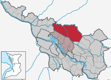
reddish grey = other parts of the Western district
Blockland is a landscape and nowadays a borough of Bremen, Germany. It is part of the Western municipal district and covers an area of 30.3 km².
Geography
The Blockland is part of the marsh of the Hamme, an affluent of Weser River, and its main source called Wümme, which are liable to the tide. The mean level is 1 metre above sea level. Wihtout the dikes along Hamme and Wümme, it would be flooded twice daily.
Since its cultivation in the 12th century, it is drained by a network of parallel trenches, cutting the area in blocks, giving this countryside its name.
Population and landuse
The density of population is quite low, 14 inhabitants per km². The settlements are concentrated along the dike. Most of the landuse is greenland economy of pastures and meadows.[1]
For the inhabitants of Bremen, the Blockland is an important leasure resort. Cycling, hiking and scating on the small roads at the dikes and along Kleine Wümme, an affluent of the Wümme, are popular spacetime activities. The Kleine Wümme and the limiting waterways of Wümme and Kuhgraben are used for paddling. And if there is enough frost, the ancient navigation canal of Semkenfahrt becomes a natural ice-rink.
The garbage dump of Bremen City, called Blockland-Deponie,[2] is situated just outside the political Blockland in the territory of the borough of Walle.
-
Wasserhorst parish church
-

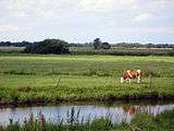
Typical landuse
-

Typical farmhouse on the dike
Cultural heritage
The oldest building of the Blockland is the tower of the evangelical parish church of Wasserhorst (DE). The church was mentioned first in 1185. The tower, in a Romano-Gothic borderline style, was erected in the 13th century. The nave was remodeled in 1743. To keep them safe from inundations, the church and churchyard have been built on an artificial hill (Ger. Warft), here based on a natural hill that had not been high enough to be safe.
References
External links
Coordinates: 53°08′35″N 08°48′22″E / 53.14306°N 8.80611°E