U Street
|
Greater U Street Historic District | |
 | |
|
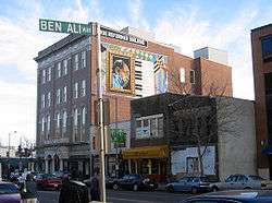
G. Byron Peck's Duke Ellington mural on the True Reformer Building, as seen from across the street at Ben Ali Way — named for the late owner of Ben's Chili Bowl. | |
| Location |
Roughly bounded by New Hampshire Avenue, Florida Avenue, 6th Street, R Street, and 16th Street, NW Washington, D.C. |
|---|---|
| Architectural style | Art Deco, Neoclassicism, Italianate, Queen Anne, Renaissance Revival, Romanesque Revival (approximately 1580 contributing properties)[1] |
| NRHP Reference # | 98001557[2] |
| Added to NRHP | December 31, 1998 |
The U Street Corridor is a commercial and residential district in Northwest Washington, D.C, U.S.A., with many shops, restaurants, nightclubs, art galleries, and music venues along a nine-block stretch of U Street. It extends from 9th Street on the east to 18th Street and Florida Avenue on the west. Most of the area is part of the larger Shaw neighborhood, with the western end entering the Dupont Circle neighborhood. It is served by the U Street Washington Metro station.
History
U Street is largely a Victorian-era neighborhood, developed between 1862 and 1900, the majority of which has been designated a historic district. The area is made up of row houses constructed rapidly by speculative builders and real estate developers in response to the city's high demand for housing following the Civil War and the growth of the federal government in the late 19th century. The corridor became commercially significant when a streetcar line operated there in the early 20th century, making it convenient for the first time for government employees to commute downtown to work and shop.[3]
Until the 1920s, when it was overtaken by Harlem, the U Street Corridor was home to the nation's largest urban African American community.[4] In its cultural heyday, it was known as "Black Broadway", a phrase coined by singer Pearl Bailey.[5] Duke Ellington's childhood home was located on 13th street between T and S Streets. The Lincoln Theatre opened in 1921, and Howard Theatre in 1926.[6]

While the area remained a cultural center for the African American community through the 1960s, the neighborhood began to decline following the assassination of Martin Luther King, Jr. in 1968. The intersection of 14th Street and U Street was the epicenter of violence and destruction during the 1968 Washington, D.C. riots. Following the riots, and the subsequent flight of affluent residents and businesses from the area, the corridor became blighted. Drug trafficking rose dramatically in the mid-1970s, when the intersection of 14th and U Streets was an area of drug trafficking in Washington, D.C.[7]
In the 1990s, revitalization of Adams Morgan and later Logan Circle began. More than 2,000 luxury condominiums and apartments were constructed between 1997 and 2007.
Architecture
The neighborhood includes the works of African American architects, including John Lankford, who was then referred to as the "dean of black architecture" and noted for the True Reformer Building at 1200 U Street NW. Other architectural designs by African Americans in the area are the Minnehaha Nickelodeon Theater by P. A. Hurlehaus, Industrial Savings Bank by Isaish T. Hatton, and Prince Hall Masonic Temple by Albery Cassell. a[8]
Redevelopment
Following the economic downturn the area faced following riots after Martin Luther King Jr's assassination, the community has made redevelopment a priority to return the area to provide desirable commercial products. Examples of those development efforts are the Reeves Center, located at the intersection of 14th Street and U Street, by city investments totaling $50 million, increased accessibility with Metrorail and bus stops on U Street, the implementation of Capital Bikeshare, funding by the Department of Housing and Urban Development promoted historical significance known as "Remembering U Street", new construction as well as rehabilitation projects provided more quality housing in the area. These housing additions include affordable housing through Section 8 vouchers and senior citizen communities.
Music, arts and culture
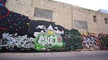
U Street has long been a center of Washington's music scene, with the Lincoln Theatre, Howard Theatre, Bohemian Caverns, and other clubs and historic jazz venues. The 9:30 Club, the Black Cat, DC9, U Street Music Hall, and the Velvet Lounge musical venues are located on the corridor, which is also home to the D.C. music collective Spelling for Bees.[9] U Street also hosts the annual Funk Parade, a festival and celebration of funk music, community arts, and creativity. Public art, graffiti and murals can be found on almost every corner along U Street.
Great Places in America
In 2011, U Street NW was designated a Great Street among Great Places in America by the American Planning Association. It is said to have been selected for in recognition of the street return to its grandeur after several decades of difficulties. Once again, the street hosts the arts, food, and businesses. The community works to embrace its historical significance for the African American community of Washington, D.C during segregation.[10]
See also
- Mary Ann Shadd Cary House
- National Register of Historic Places listings in Northwest Quadrant, Washington, D.C.
References
- ↑ "District of Columbia - Inventory of Historic Sites" (PDF). District of Columbia: Office of Planning. Government of the District of Columbia. September 1, 2004. Retrieved August 8, 2009.
- ↑ Staff (2009-03-13). "National Register Information System". National Register of Historic Places. National Park Service.
- ↑ Greater U Street Historic District
- ↑ U Street/Shaw
- ↑ Duke Ellington's Jazz Tour, Site Seeing Tours
- ↑ Kaiser, Robert G. (April 22, 2004). "A City of Splendid Spaces, Great Events; 4 Landmarks Offer Washingtonians Gateways to a Capital Adventure". The Washington Post.
- ↑ Lusane, Clarence Pipe Dream Blues: Racism and the War on Drugs South End Press, Boston 1991, ISBN 0-89608-410-8
- ↑ "2011 Great Places in America". U Street NW, Washington, D.C. American Planning Association.
- ↑ "Music". The Washington Post.
- ↑ "2011 Great Places in America". American Planning Association.
External links
| Wikimedia Commons has media related to U Street/Shaw. |
- Alt, Alicia (April 14, 2006). "U Street: The Corridor Is Cool Again". New York Times.
- Kiviat, Barbara (May 9, 2005). "U in the District". Time.
- Kuan, Diana (January 28, 2007). "U Street, Adams Morgan humming again". Boston Globe.
- Wiltz, Teresa (March 5, 2006). "U Turn". Washington Post. p. W24.
| ||||||||||||||||||||||||||||||||||
Coordinates: 38°55′1.2″N 77°1′46.5″W / 38.917000°N 77.029583°W
