Prince-Bishopric of Strasbourg
| Prince-Bishopric of Strassburg | ||||||
| Bistum Strossburi (als) Fürstbistum Straßburg (de) | ||||||
| State of the Holy Roman Empire | ||||||
| ||||||
| ||||||
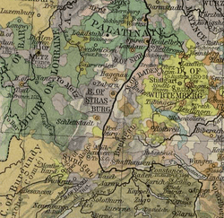 The Prince-Bishopric of Strassburg, circa 1547 | ||||||
| Capital | Strassburg | |||||
| Government | Theocracy | |||||
| Historical era | Middle Ages | |||||
| • | Prince-Bishopric founded | before 343 | ||||
| • | Gained autonomy | 775 | ||||
| • | Imperial immediacy | 982 | ||||
| • | Left-bank territories annexed by France |
1681 | ||||
| • | Annexation recognised by the Holy Roman Empire |
1697 | ||||
| • | Right-bank territories mediatised to Baden |
1803 | ||||
| Today part of | ||||||
| Part of the series on |
| Alsace |
|---|
.svg.png) Rot un Wiss, flag of Alsace since 11th century. |
|
(including Lorraine) |
|
|
Alsace in the EU |
|
Related topics |
|
The Prince-Bishopric of Strassburg (German: Fürstbistum Straßburg) was an ecclesiastical principality of the Holy Roman Empire from the 13th century until 1803. During the late 17th century, most of its territory was annexed by France; this consisted of the areas on the left bank of the Rhine, around the towns of Saverne, Molsheim, Bevefelden, Dachstein, Dambach, Dossenheim-Kochersberg, Erstein, Kästenbolz, Rhinau, and the Mundat (consisting of Rouffach, Soultz, and Eguisheim). The annexations were recognized by the Holy Roman Empire in the Treaty of Ryswick of 1697. Only the part of the state that was to the right of the Rhine remained; it consisted of areas around the towns of Oberkirch, Ettenheim, and Oppenau. The remaining territory was secularized to Baden in 1803.
Gallery
|
See also
Notes
References
-
 "Strasburg". Catholic Encyclopedia. New York: Robert Appleton Company. 1913.
External links
| |||||||||||||||||||||||||||||||||||||
| ||||||||
| |||||||||||||||||||||||||||
Coordinates: 48°35′4″N 7°44′55″E / 48.58444°N 7.74861°E
|
.svg.png)






.svg.png)
