Bhadrapur Airport
| Chandragadi Airport Chandragadhi Airport | |||||||||||
|---|---|---|---|---|---|---|---|---|---|---|---|
 | |||||||||||
 Bhadrapur | |||||||||||
| Summary | |||||||||||
| Airport type | Public | ||||||||||
| Owner | Government Of Nepal | ||||||||||
| Operator | Government | ||||||||||
| Serves | Bhadrapur / Chandragadhi, Nepal | ||||||||||
| Elevation AMSL | 300 ft / 91 m | ||||||||||
| Coordinates | 26°34′14″N 088°04′46″E / 26.57056°N 88.07944°E | ||||||||||
| Runways | |||||||||||
| |||||||||||
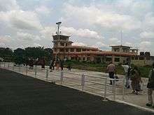
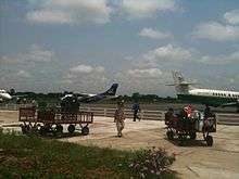
Bhadrapur Airport (IATA: BDP, ICAO: VNCG), also known as Chandragadhi Airport,[1] is an airport serving Bhadrapur and Chandragadhi,[2] both towns in the Jhapa district in the Mechi zone in Nepal. It is very small airport with no electronic equipment's.
Facilities
The airport is at 300 feet (91 m) elevation. It has one runway designated 10/28 with an asphalt surface measuring 1,209 by 29 metres (3,967 ft × 95 ft).[1]
The airport is about 3 hours by road from Darjeeling via the Pashupatinagar-Ilam route. There are border formalities at Pashupatinagar.
The airport is capable to handle aircraft from the Nepalese Army Air Service.
Airlines and destinations
Buddha Airlines BDP KTM 2 flight
Yeti Airlines BDP KTM 2 flight
Saurya Airlines BDP KTM 1 flight
Nepal Airlines BDP-KTM Weekely 2 flight
References
- 1 2 3 Airport information for VNCG from DAFIF (effective October 2006)
- 1 2 Airport information for Chandragadhi / Bhadrapur, Nepal (VNCG / BDP) at Great Circle Mapper. Source: DAFIF (effective October 2006).
Saurya air 1st jet engine airlines 30 minutes from bhadrapur to kathmandaU Daily 1 flight contact 023-455251 city Sales Chandragadi
See Also
