Beecher, Illinois
| Beecher | |
| Village | |
 Beecher, looking east | |
| Official name: Village of Beecher | |
| Country | United States |
|---|---|
| State | Illinois |
| County | Will |
| Coordinates | 41°20′27″N 87°37′17″W / 41.34083°N 87.62139°WCoordinates: 41°20′27″N 87°37′17″W / 41.34083°N 87.62139°W |
| Area | 2.96 sq mi (7.67 km2) |
| - land | 2.96 sq mi (8 km2) |
| - water | 0.00 sq mi (0 km2), 0% |
| Population | 4,359 (2010) |
| Density | 964.4 / sq mi (372.4 / km2) |
| Incorporated | 1884 |
| Mayor | Greg Szymanski |
| Timezone | CST (UTC-6) |
| - summer (DST) | CDT (UTC-5) |
| Postal code | 60401 |
| Area code | 708 |
 Location in Will County and the state of Illinois.
| |
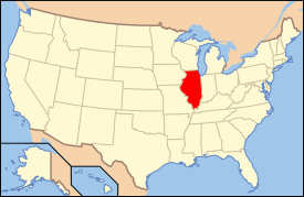
 Location of Illinois in the United States
| |
| Website: www | |
Beecher is a village in Will County, Illinois, United States. It is located on the old Chicago and Eastern Illinois Railroad and the Dixie Highway. Situated in the center of Washington Township, it was originally named Washington Center. Named for Henry Ward Beecher, Beecher was founded in 1870 and incorporated as a village in 1884. Originally governed by a village president and board of trustees, a village administrator was hired to handle daily tasks in 1988. The city clerk is an appointed position.
The population was 4,359 at the 2010 census.
Geography
According to the 2010 census, Beecher has a total area of 2.96 square miles (7.67 km2), all land.[1] The majority of the village is in Section 16 of Washington Township.
A branch of Trim Creek flows through Beecher, but this carries very little water most of the year.
Beecher is located in the center of a primarily agricultural township. Beecher Consolidated School District provides educational services for Washington Township and 12 square miles (31 km2) of the neighboring, entirely rural, Will Township.
The nearest towns are Crete, Illinois, 7 miles (11 km) north; Grant Park, 7 miles (11 km) south; Peotone, 9 miles (14 km) west and Cedar Lake, Indiana, 10 miles (16 km) east.

Demographics
| Historical population | |||
|---|---|---|---|
| Census | Pop. | %± | |
| 1890 | 342 | — | |
| 1900 | 410 | 19.9% | |
| 1910 | 543 | 32.4% | |
| 1920 | 609 | 12.2% | |
| 1930 | 772 | 26.8% | |
| 1940 | 742 | −3.9% | |
| 1950 | 956 | 28.8% | |
| 1960 | 1,367 | 43.0% | |
| 1970 | 1,770 | 29.5% | |
| 1980 | 2,024 | 14.4% | |
| 1990 | 2,032 | 0.4% | |
| 2000 | 2,033 | 0.0% | |
| 2010 | 4,359 | 114.4% | |
| Est. 2014 | 4,461 | [2] | 2.3% |
As of the census[4] of 2000, there were 2,033 people, 830 households, and 590 families residing in the village. The population density was 964.4 people per square mile (372.0/km²). There were 876 housing units at an average density of 415.6 per square mile (160.3/km²). The racial makeup of the village was 98.03% White, 0.15% Native American, 0.44% Asian, 0.34% from other races, and 1.03% from two or more races. Hispanic or Latino of any race were 1.77% of the population and 0.00% African American.
There were 830 households out of which 29.4% had children under the age of 18 living with them, 59.4% were married couples living together, 8.6% had a female householder with no husband present, and 28.9% were non-families. 26.4% of all households were made up of individuals and 13.1% had someone living alone who was 65 years of age or older. The average household size was 2.45 and the average family size was 2.96.
In the village the population was spread out with 22.8% under the age of 18, 7.1% from 18 to 24, 25.0% from 25 to 44, 27.0% from 45 to 64, and 18.2% who were 65 years of age or older. The median age was 42 years. For every 100 females there were 91.4 males. For every 100 females age 18 and over, there were 91.2 males.
The median income for a household in the village was $51,250, and the median income for a family was $60,625. Males had a median income of $43,563 versus $26,786 for females. The per capita income for the village was $23,454. About 3.0% of families and 4.0% of the population were below the poverty line, including 4.2% of those under age 18 and 9.0% of those age 65 or over.
Notable person
- Rube Ehrhardt, pitcher for the Brooklyn Robins , Cincinnati Reds
References
- ↑ "G001 - Geographic Identifiers - 2010 Census Summary File 1". United States Census Bureau. Retrieved 2015-08-02.
- ↑ "Annual Estimates of the Resident Population for Incorporated Places: April 1, 2010 to July 1, 2014". Retrieved June 4, 2015.
- ↑ "Census of Population and Housing". Census.gov. Retrieved June 4, 2015.
- ↑ "American FactFinder". United States Census Bureau. Retrieved 2008-01-31.
External links
| Wikimedia Commons has media related to Beecher, Illinois. |
| |||||||||||||||||||||||||||||||||||||
| |||||||||||||||||||||||||||||||||
