Beardsley Dam

Beardsley Dam (National ID # CA00263) is a dam in Tuolumne County, California.
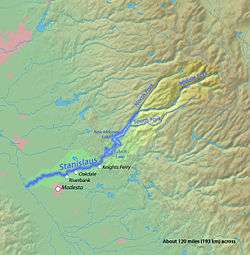
The earthen dam was completed in 1957 with a height of 284 feet (87 m), and a length of 1,000 feet (300 m) at its crest.[1] It impounds the Middle Fork of the Stanislaus River for hydroelectric power and irrigation water storage, part of the Stanislaus River Tri-Dam project cooperatively owned by the Oakdale Irrigation District and South San Joaquin Irrigation District.[2] The site is surrounded by the Stanislaus National Forest.
The reservoir it creates, Beardsley Lake, was a water surface of 1.1 square miles, a maximum capacity of 97,800 acre feet (120,600,000 m3), and a normal capacity of 97,500 acre feet (120,300,000 m3).[3] Recreation includes camping, fishing, and boating.[4]
See also
References
Coordinates: 38°12′15″N 120°04′28″W / 38.20425°N 120.07447°W