Bear Lake National Wildlife Refuge
| Bear Lake National Wildlife Refuge | |
|---|---|
|
IUCN category IV (habitat/species management area) | |
|
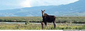
A moose and her young in Bear Lake National Wildlife Refuge. USFWS photo. | |
 Map of the United States | |
| Location | Bear Lake County, Idaho, United States |
| Nearest city | Montpelier, Idaho |
| Coordinates | 42°09′48″N 111°18′45″W / 42.16326°N 111.31242°WCoordinates: 42°09′48″N 111°18′45″W / 42.16326°N 111.31242°W[1] |
| Area | 19,000 acres (77 km2) |
| Established | 1968 |
| Governing body | U.S. Fish and Wildlife Service |
| http://www.fws.gov/bearlake/ | |
Bear Lake National Wildlife Refuge is located in southeast Idaho, seven miles (11 km) south of Montpelier. Surrounded by mountains, it lies in Bear Lake Valley at an elevation ranging from 5,925 feet (1,806 m) on the marsh to 6,800 feet (2,100 m) on the rocky slopes of Merkley Mountain. The refuge office is located in Montpelier.
The 19,000-acre (77 km2) refuge is mainly made up of a bulrush marsh, open water, and flooded meadows of sedges, rushes, and grasses. Portions of the refuge include scattered grasslands and brush-covered slopes.
Bear Lake Refuge encompasses what is locally referred to as Dingle Swamp or Dingle Marsh. Along with Bear Lake proper, the marsh was once part of a larger prehistoric lake that filled the valley. As it drained and receded, Dingle Marsh was reduced from 25,000 acres (100 km2) to less than 17,000 before it became part of the refuge.
See also
References
- ↑ "Bear Lake National Wildlife Refuge". Geographic Names Information System. United States Geological Survey.
![]() This article incorporates public domain material from websites or documents of the United States Fish and Wildlife Service.
This article incorporates public domain material from websites or documents of the United States Fish and Wildlife Service.
