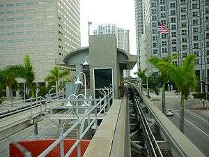
Bayfront Park station
Bayfront Park | |||||||||||||||||||||
|---|---|---|---|---|---|---|---|---|---|---|---|---|---|---|---|---|---|---|---|---|---|
| Metromover people mover station | |||||||||||||||||||||
 View from Downtown Loop car approaching the station | |||||||||||||||||||||
| Location |
150 Biscayne Boulevard Miami, Florida 33132 | ||||||||||||||||||||
| Coordinates | 25°46′23″N 80°11′14″W / 25.77306°N 80.18722°WCoordinates: 25°46′23″N 80°11′14″W / 25.77306°N 80.18722°W | ||||||||||||||||||||
| Owned by | Miami-Dade County | ||||||||||||||||||||
| Line(s) | |||||||||||||||||||||
| Platforms | 1 island platform | ||||||||||||||||||||
| Tracks | 2 | ||||||||||||||||||||
| Connections |
| ||||||||||||||||||||
| Construction | |||||||||||||||||||||
| Disabled access | Yes | ||||||||||||||||||||
| Other information | |||||||||||||||||||||
| Fare zone | |||||||||||||||||||||
| History | |||||||||||||||||||||
| Opened | April 17, 1986 | ||||||||||||||||||||
| Services | |||||||||||||||||||||
| |||||||||||||||||||||
Bayfront Park is a Metromover station in Downtown, Miami, Florida, adjacent to Bayfront Park.
This station is located at the intersection of Southeast Second Street and Biscayne Boulevard (US 1), opening to service April 17, 1986.
The station sees very heavy ridership during special events such as New Year's Eve, when service is extended to 2 a.m.[1]
Places of interest
- Hotel Intercontinental
- Bayfront Park
- Miami Center
- One Bayfront Plaza
- One Biscayne Tower
- Southeast Financial Center
- One Miami
- 50 Biscayne
- Atrium Tower
- Met 3
- Met 1
- Edward Ball Center
- Met 2/JW Marriott
Transit connections
Metrobus
| Route # | Route Name | Route Map | Note |
|---|---|---|---|
| 3 | Downtown Miami ↔ Aventura Mall or Hallandale Beach via Biscayne Blvd | Map | |
| 11 | Downtown Miami ↔ FIU University Park Campus via Flagler St & SW 107 Ave (SR 985) | Map | Westbound trips only |
| 16 | Downtown Miami ↔ The Mall at 163rd Street via NE 2 Ave, North Miami Blvd (SR 922), and NE 16 Ave | Map | |
| 48 | Santa Clara Station ↔ South Miami Station | Map | |
| 51 | Flagler MAX (Miami Beach ↔ West Miami to 137 Ave via Flagler St) | Map | Weekdays only; limited-stop |
| 77 | Downtown Miami ↔ Miami Gardens @ 183 St or 199 St via 7 Ave and NW 2 Ave (US 441) | Map | |
| 95 | Aventura ↔ Brickell | Map | Weekdays only; limited-stop |
| C (103) | Downtown Miami ↔ Miami Beach at Mount Sinai Hospital | Map | |
| S (119) | Aventura Mall via Miami Beach | Map | |
References
- ↑ "Miami-Dade Transit extends service for New Year's celebrations in downtown Miami". Miami-Dade County. December 29, 2011. Retrieved October 9, 2015.
External links
-
 Media related to Bayfront Park metro station at Wikimedia Commons
 - MDT – Metromover Stations
- entrance from Google Maps Street View
This article is issued from Wikipedia - version of the Tuesday, December 29, 2015. The text is available under the Creative Commons Attribution/Share Alike but additional terms may apply for the media files.