Armadale, West Lothian
| Armadale | |
| Scottish Gaelic: Armadal[1] | |
| Scots: Airmadale[2][3] | |
 Coia's Sweet Shop and The Goth, looking eastwards. |
|
 Armadale |
|
| Population | 9,063 [4] (2001 census) est. 10,830[5] (2006) |
|---|---|
| OS grid reference | NS935685 |
| Council area | West Lothian |
| Lieutenancy area | West Lothian |
| Country | Scotland |
| Sovereign state | United Kingdom |
| Post town | BATHGATE |
| Postcode district | EH48 |
| Dialling code | 01501 |
| Police | Scottish |
| Fire | Scottish |
| Ambulance | Scottish |
| EU Parliament | Scotland |
| UK Parliament | Linlithgow and East Falkirk |
| Scottish Parliament | Linlithgow |
Coordinates: 55°53′52″N 3°42′17″W / 55.897801°N 3.704736°W
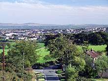
Armadale (Scots: Airmadale, Scottish Gaelic: Armadal) is a town within the district of West Lothian in central Scotland. Armadale, formerly known as Barbauchlaw, is an ex-mining town which is also known for its brick manufacturing.[6] It is named after Armadale in Sutherland,[7] this estate being owned by Sir William Honeyman who later acquired the land of Barbauchlaw.[8]
Overview
The town has a great number of different public places. There are eight public bars in the town - Coppies Bar, The Corrie, The Crack Den , The Cavalier, The Bucks Head Tavern, The Highlander, The Regal, and The Goth, which provides the town clock at the front of the building. There are local shops like Coia's Sweet Shop, Coia's Fish and Chip shop, John Dewar and Sons Butchers and more. The main feature of Armadale is The Cross. There is also a small Scotmid supermarket on West Main Street.


Armadale (Woodend Farm) is officially the site of Ogilface Castle.[9] Woodend Farm has another site nearer Blackridge, marked as 'Ogelface in ruins' on a 1773 map.[10] These sites have been the subject of archaeological geophysics surveys[11] by the Edinburgh Archaeological Field Society and Dr Peter Morris[12] and kite aerial photography[13] by the West Lothian Archaeological Trust which now also manages the Armadale Community and Heritage Website.[14]
History
Before the building of a new turnpike road between Edinburgh and Glasgow in 1786 the village of Armadale was little more than a rural farm community but its location at a main highway junction brought additional traffic and a toll house was built where the new road intersected with an existing road in the east of the estate.[15] The estate comprising the lands of Barbauchlaw was sold to Sir William Honeyman in 1790 [15] and upon his elevation to the bench in 1797 he took the title of Lord Armadale (from his mother's estate in Sutherland) and this name was then applied to the township [16]
The discovery of large coal deposits and also ironstone in the area attracted the attention of a number of companies and several pits were sunk in the area.[17] A coal company was formed in 1819 and began to work the "Woodend Pit" to the north-west of the toll house.[15] The resulting boost in prosperity brought railway companies onto the scene transporting an influx of workers requiring housing and all the usual attendant facilities such as shops, village halls, churches etc.. A school was first formed in the town also in this year, and it eventually became necessary to build a dedicated school house in 1839 to accommodate the growing number of students.[15]
As with most mineral dependant communities, as the deposits were exhausted and the pits closed, many moved away but enough local industry remained for the township to survive and today it has also become a commuting hub for those employed in the major towns.
Transport
The station at Armadale, first opened by the defunct Bathgate and Coatbridge Railway[18] was constructed as part of the Airdrie-Bathgate Rail Link in the south end of Armadale and re-opened on 4 March 2011.[19]
Culture and sport
Armadale Stadium features greyhound racing and speedway.[20] It was also used in the past for stock car racing. Speedway started in 1997 when the Edinburgh Monarchs[21] team moved there and has now competed for ten seasons at the venue. The team won the Premier League in 2003, however Armadale Stadium is soon to be closed and demolished to make way for a new supermarket. The town also has a long-established football team, Armadale Thistle, whose home, Volunteer Park, is located on North Street.
The Armadale Flute Band, established in 1983, have won competitions all over Scotland.
In May 2013, following the death of Trustee Rosie Wells, and her subsequent bequest, the Armadale registered Scottish Charity No SC043118 (The West Lothian Archaeological Trust) set up the Scottish National Aerial Photography Scheme for children and students. International recognition came in the same month, with the Trust being invited to become an Associated Partner of the ArchaeoLandscapes Europe Project, part of the European Union's Culture Programme, which is managed by Dr Axel Posluschny of the Roman-Germanic Commission of the German Archaeological Institute.
Education

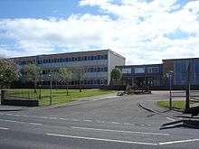
The local high school Armadale Academy[22] was originally built at the site that now plays host to Armadale Primary School. It was rebuilt and opened in 1967, at West Main Street, Armadale, and was again rebuilt and opened in August 2009, immediately behind the 1967 Academy building. The site of the old building will be used for new car parking facilities, and new playing fields. The current headmaster is Campbell Hornell. The old headmaster, Graham Johnstone retired at the end of the 2009/10 term being headmaster there for nearly fourteen years of service.The school has a seasonal magazine named, "Aloha Armadale". The team is made up of pupils in the school.

Famous residents
See Category:People from Armadale, West Lothian
- William Angus, recipient of the Victoria Cross
- Writer Tom Hanlin[23] was born in Armadale in 1907.
- Ian Ellis, member of pioneering 60s/70s band Clouds, as well as many other famous bands of that era.[24]
References
- ↑ http://www.scottish.parliament.uk/vli/language/gaelic/vl-trans.htm
- ↑ Andy Eagle. "The Online Scots Dictionary". Scots Online.
- ↑ http://newsnetscotland.com/index.php/component/content/article/2999-list-of-railway-station-names.html
- ↑ "Comparative Population Profile: Armadale Locality". Scotland's Census Results Online. 2001-04-29. Retrieved 2008-08-31.
- ↑ "www.gro-scotland.gov.uk/statistics/publications-and-data".
- ↑ "Employment and Industries". armadale.org.uk.
- ↑ "Thumbnail Gallery : Scarfskerry : 1 to 6 of 6 images". caithness.org.
- ↑ "Sir William Honeyman, Lord Armadale". armadale.org.uk. line feed character in
|title=at position 28 (help) - ↑ ""Ogelface Castle - Woodend Site Photos"". armadale.org.uk.
- ↑ ""Ogelface in Ruins - Blackridge Site Photos"". armadale.org.uk.
- ↑ "West Lothian Archaeology Group". armadale.org.uk.
- ↑ http://www.eafs.org.uk/
- ↑ "Kite Aerial Photography ( KAP )". kiteaerialphotography.org.uk.
- ↑ "West Lothian Archaeological Trust". armadale.org.uk.
- 1 2 3 4 "The History of Armadale". Retrieved 2010-12-27.
- ↑ Hood, John (2008). Old Armadale and Blackridge. Catrine, Ayrshire: Stenlake Publishing. ISBN 9781840334166.
- ↑ Hood, John (2007). Old Armadale. Catrine, Ayrshire: Stenlake Publishing. ISBN 9781840334166.
- ↑ "Bathgate and Coatbridge Railway". Archived from the original on 6 December 2007. Retrieved 2008-01-06.
- ↑ "Airdrie-Bathgate Rail Link". Retrieved 2008-01-06.
- ↑ Bamford, R; Jarvis, J (2001). Homes of British Speedway. ISBN 0-7524-2210-3.
- ↑ Henry, J; Moultray, I (2001). Speedway in Scotland. ISBN 0-7524-2229-4.
- ↑ "www.westlothian.org.uk/armadaleacademy/".
- ↑ "www.armadale.org.uk/tomhanlin.htm".
- ↑ The Encyclopaedia of Popular Music (Muze publications)
External links
| Wikimedia Commons has media related to Armadale, West Lothian. |
- Armadale's community website
- Armadale Thistle FC (Archived 2009-10-25)
- Edinburgh Speedway
- History of Armadale
- Airdrie to Bathgate Rail Link
|