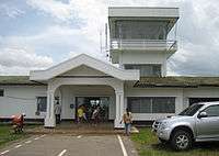
Ban Huoeisay Airport
Ban Huoeisay Airport (Lao: ສະໜາມບິນບໍ່ແກ້ວ, Vietnamese: Sân bay Ban Huoeisay) (IATA: HOE, ICAO: VLHS) is an airport in Ban Houayxay, Laos. Alternative spellings are Ban Houayxay Airport, Ban Houei Sai Airport and Ban Huay Xai Airport.
Airlines and destinations
Accidents and incidents
References
- ↑ Airport information for VLHS at World Aero Data. Data current as of October 2006.
- ↑ Airport information for HOE at Great Circle Mapper.
- ↑ Accident history for VLHS / HOE at Aviation Safety Network
- ↑ "XW-TDI Accident description". Aviation Safety Network. Retrieved 19 September 2010.
- ↑ "Xray Whiskey Registration File". Thomas E Lee. Retrieved 27 September 2010.

