Balingoan, Misamis Oriental
| Balingoan | |
|---|---|
| Municipality | |
| Municipality of Balingoan | |
|
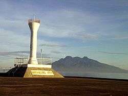
Balingoan pier with Camiguin in the background | |
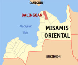
 Map of Misamis Oriental with Balingoan highlighted | |
.svg.png) Balingoan Location within the Philippines | |
| Coordinates: 09°00′N 124°51′E / 9.000°N 124.850°ECoordinates: 09°00′N 124°51′E / 9.000°N 124.850°E | |
| Country | Philippines |
| Region | Northern Mindanao (Region X) |
| Province | Misamis Oriental |
| District | 1st district of Misamis Oriental |
| Founded | March 1, 1952 |
| Barangays | 9 |
| Government[1] | |
| • Mayor | Pedro Panulaya |
| Area[2] | |
| • Total | 57.80 km2 (22.32 sq mi) |
| Population (2010)[3] | |
| • Total | 10,175 |
| • Density | 180/km2 (460/sq mi) |
| Time zone | PST (UTC+8) |
| ZIP code | 9011 |
| Dialing code | 88 |
| Income class | 5th |
Balingoan is a fifth class municipality in the province of Misamis Oriental, Philippines. According to the 2010 census, it has a population of 10,175 people.[3]
Barangays
Balingoan is politically subdivided into 9 barangays.[2]
- Baukbauk (Pob.)
- Dahilig
- Kabangasan
- Kabulakan
- Kauswagan
- Lapinig (Pob.)
- Mantangale
- Mapua
- San Alonzo
History
Formerly part of Talisayan, it gained independence on March 1, 1952. According to the local legend,it derived its name from the word "baling ni juan" (John's Fishing Net), which later on became simply as "Balingoan".
Demographics
| Population census of Balingoan | ||
|---|---|---|
| Year | Pop. | ±% p.a. |
| 1990 | 6,689 | — |
| 1995 | 7,548 | +2.29% |
| 2000 | 8,197 | +1.78% |
| 2007 | 9,021 | +1.33% |
| 2010 | 10,175 | +4.48% |
| Source: National Statistics Office[3] | ||
Economy
Produce: Copra, fish, sea shells, fruits, vegetables, animal meat, and dairy products.
Culture
Feast day: May 29. Patron Saint: Saint Alonzo de Rodriguez
Transportation
Port of Balingoan is the main port for travellers going to the provincial island of Camiguin. From Cagayan de Oro to Balingoan is about 86 kilometres (53 mi) and would take around 1.5 hours bus ride.
Education
There are 9 Public Elementary Schools situated in Barangays San Alonzo, Bauk-bauk, Lapinig, Mantangale, Mapua, Kauswagan, Kabulakan, Dahilig and Kabangasan.
Currently, there is a National High School located at Mantangale, and is called Mantangale National High School. Pre-school facilities both Public and Privately operated exists.
References
- ↑ "Official City/Municipal 2013 Election Results". Intramuros, Manila, Philippines: Commission on Elections (COMELEC). 1 July 2013. Retrieved 5 September 2013.
- 1 2 "Province: MISAMIS ORIENTAL". PSGC Interactive. Makati City, Philippines: National Statistical Coordination Board. Retrieved 26 June 2014.
- 1 2 3 "Total Population by Province, City, Municipality and Barangay: as of May 1, 2010" (PDF). 2010 Census of Population and Housing. National Statistics Office. Retrieved 26 June 2014.
External links
- Municipality of Balingoan
- Philippine Standard Geographic Code listing for Balingoan - National Statistical Coordination Board
- Local Governance Performance Management System
 |
Guinsiliban, Camiguin Bohol Sea |
 | ||
| Kinoguitan Sugbongcogon |
|
Talisayan | ||
| ||||
| | ||||
| Salay | Claveria |
| ||||||||||||||||||
