Baldwin, Georgia
| Baldwin, Georgia | |
|---|---|
| City | |
|
Willingham Avenue in Baldwin | |
| Motto: "The Hub of Development in Northeast Georgia" | |
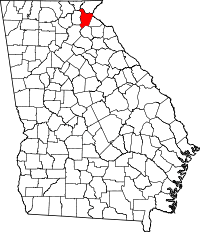
 Location in Banks County and the state of Georgia | |
| Coordinates: 34°29′27″N 83°33′10″W / 34.49083°N 83.55278°W | |
| Country | United States |
| State | Georgia |
| Counties | Habersham, Banks |
| Area | |
| • Total | 4.9 sq mi (12.7 km2) |
| • Land | 4.9 sq mi (12.7 km2) |
| • Water | 0 sq mi (0 km2) |
| Elevation | 1,529 ft (466 m) |
| Population (2010) | |
| • Total | 3,279 |
| • Density | 668/sq mi (258.0/km2) |
| Time zone | Eastern (EST) (UTC-5) |
| • Summer (DST) | EDT (UTC-4) |
| ZIP code | 30511 |
| Area code(s) | 706 |
| FIPS code | 13-04980[1] |
| GNIS feature ID | 0354438[2] |
| Website |
www |
Baldwin is a city in Banks and Habersham counties in the U.S. state of Georgia. As of the 2010 census, the city had a population of 3,279.[3]
Baldwin is located on U.S. Route 441 just south of Georgia State Route 365. Baldwin sits astride the Eastern Continental Divide, which separates waters flowing southeastward toward the Savannah River and the Atlantic Ocean from waters flowing southwestward toward the Chattahoochee River and the Gulf of Mexico. City Hall sits in Habersham County. Baldwin borders the bigger city of Cornelia, which has the Habersham Chamber of Commerce. Nearby in Demorest is Piedmont College. Also nearby is Lake Russell, a recreation area in Chattahoochee National Forest. The Habersham County airport is in Baldwin. The biggest employer is Fieldale Corporation, a large chicken processing company.
Geography
Baldwin is located in northeastern Georgia at 34°29′27″N 83°33′10″W / 34.490757°N 83.552643°WCoordinates: 34°29′27″N 83°33′10″W / 34.490757°N 83.552643°W.[4]
According to the United States Census Bureau, the city has a total area of 4.9 square miles (12.7 km2), all of it land.[5]
Demographics
| Historical population | |||
|---|---|---|---|
| Census | Pop. | %± | |
| 1900 | 130 | — | |
| 1910 | 280 | 115.4% | |
| 1920 | 193 | −31.1% | |
| 1930 | 319 | 65.3% | |
| 1940 | 402 | 26.0% | |
| 1950 | 490 | 21.9% | |
| 1960 | 698 | 42.4% | |
| 1970 | 772 | 10.6% | |
| 1980 | 1,080 | 39.9% | |
| 1990 | 1,439 | 33.2% | |
| 2000 | 2,425 | 68.5% | |
| 2010 | 3,279 | 35.2% | |
| Est. 2014 | 3,309 | [6] | 0.9% |
As of the census[1] of 2000, there were 2,425 people, 845 households, and 583 families residing in the city. The population density was 674.9 people per square mile (260.8/km²). There were 912 housing units at an average density of 253.8 per square mile (98.1/km²). The racial makeup of the city was 83.22% White, 3.71% African American, 0.33% Native American, 2.43% Asian, 0.82% Pacific Islander, 6.89% from other races, and 2.60% from two or more races. Hispanic or Latino of any race were 25.86% of the population.
There were 845 households out of which 36.6% had children under the age of 18 living with them, 51.2% were married couples living together, 12.4% had a female householder with no husband present, and 30.9% were non-families. 26.2% of all households were made up of individuals and 8.6% had someone living alone who was 65 years of age or older. The average household size was 2.71 and the average family size was 3.26.
In the city the population was spread out with 26.2% under the age of 18, 13.5% from 18 to 24, 29.4% from 25 to 44, 16.3% from 45 to 64, and 14.6% who were 65 years of age or older. The median age was 30 years. For every 100 females there were 97.3 males. For every 100 females age 18 and over, there were 90.1 males.
The median income for a household in the city was $29,299, and the median income for a family was $33,011. Males had a median income of $25,409 versus $21,823 for females. The per capita income for the city was $14,059. About 20.0% of families and 26.4% of the population were below the poverty line, including 32.5% of those under age 18 and 33.8% of those age 65 or over.
History
Habersham County was created in 1818 from Indian treaty lands. Georgia's 43rd county was named for Major Joseph Habersham, who fought in the Revolutionary War, was mayor of Savannah, served in Congress and was President George Washington's Postmaster General.
External links
References
- 1 2 "American FactFinder". United States Census Bureau. Retrieved 2008-01-31.
- ↑ "US Board on Geographic Names". United States Geological Survey. 2007-10-25. Retrieved 2008-01-31.
- ↑ http://factfinder2.census.gov/faces/tableservices/jsf/pages/productview.xhtml?pid=DEC_10_SF1_GCTP2.ST13&prodType=table
- ↑ "US Gazetteer files: 2010, 2000, and 1990". United States Census Bureau. 2011-02-12. Retrieved 2011-04-23.
- ↑ "Geographic Identifiers: 2010 Demographic Profile Data (G001): Baldwin city, Georgia". U.S. Census Bureau, American Factfinder. Retrieved October 29, 2013.
- ↑ "Annual Estimates of the Resident Population for Incorporated Places: April 1, 2010 to July 1, 2014". Retrieved June 4, 2015.
- ↑ "Census of Population and Housing". Census.gov. Retrieved June 4, 2015.
| |||||||||||||||||||||||||
| |||||||||||||||||||||||||||||

