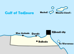
Balbala
| Balbala | |
|---|---|
 Location of Balbala | |
| Coordinates: 11°33′43″N 43°05′52″E / 11.56194°N 43.09778°ECoordinates: 11°33′43″N 43°05′52″E / 11.56194°N 43.09778°E | |
| Country |
|
| Region | Djibouti Region |
| Elevation | 60 m (200 ft) |
| Population | |
| • Total | 223,043 |
| Time zone | East Africa Time (UTC+3) |
Balbala is a southern suburb of Djibouti city, located west of the river Ambouli.[1] The name is from the "Flashing" (on Somali bal-bal be derived) from the nearby lighthouse.
History
After riots in 1966 a checkpoint was erected in front of the capital of the former French colony to discourage "subversive elements" at the entrance to the city. Upstream of this checkpoint developed a settlement of migrants from other parts of the country, an informal cattle market and a caravan station. Police raids in the city and the subsequent deportation of unwanted newcomers further contributed to the growth of Balbala, which was a large slum.
After the independence of Djibouti in 1977, the checkpoint was lifted and Balbala formally transformed into a residential area and integrated into the urban development of Djibouti. Since 1987, it has officially been part of the city. In the first decade after independence, the population of Balbala had tripled again. It then became a new urban district, from the rural exodus. Building rights were gradually transferred to the occupants, and the area acquired urban characteristics, with solid construction and schools and other services.
As of (2000) Balbala had four primary schools and the second largest hospital in the country, and its reputation had improved. The population was then estimated at 80,000.