Badefols-sur-Dordogne
| Badefols-sur-Dordogne | |
|---|---|
 | |
 Badefols-sur-Dordogne | |
|
Location within Aquitaine region  Badefols-sur-Dordogne | |
| Coordinates: 44°50′39″N 0°47′32″E / 44.8442°N 0.7922°ECoordinates: 44°50′39″N 0°47′32″E / 44.8442°N 0.7922°E | |
| Country | France |
| Region | Aquitaine-Limousin-Poitou-Charentes |
| Department | Dordogne |
| Arrondissement | Bergerac |
| Canton | Buisson-de-Cadouin |
| Intercommunality | Cadouin |
| Government | |
| • Mayor (2008–2014) | Michel Couderc |
| Area1 | 6.06 km2 (2.34 sq mi) |
| Population (2008)2 | 206 |
| • Density | 34/km2 (88/sq mi) |
| INSEE/Postal code | 24022 / 24150 |
| Elevation |
35–180 m (115–591 ft) (avg. 46 m or 151 ft) |
|
1 French Land Register data, which excludes lakes, ponds, glaciers > 1 km² (0.386 sq mi or 247 acres) and river estuaries. 2 Population without double counting: residents of multiple communes (e.g., students and military personnel) only counted once. | |
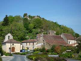
Badefols-sur-Dordogne (Occitan: Badafòl) is a commune in the Dordogne department in southwestern France. The commune is situated on the Dordogne River.
Population
| Historical population | ||
|---|---|---|
| Year | Pop. | ±% |
| 1962 | 172 | — |
| 1968 | 173 | +0.6% |
| 1975 | 143 | −17.3% |
| 1982 | 150 | +4.9% |
| 1990 | 188 | +25.3% |
| 1999 | 187 | −0.5% |
| 2008 | 206 | +10.2% |
History
In 1952, the commune of Badefols-de-Cadouin was renamed Badefols-sur-Dordogne.
See also
References
External links
| Wikimedia Commons has media related to Badefols-sur-Dordogne. |
This article is issued from Wikipedia - version of the Wednesday, September 16, 2015. The text is available under the Creative Commons Attribution/Share Alike but additional terms may apply for the media files.