Bad Dürrheim
| Bad Dürrheim | ||
|---|---|---|
| ||
 Bad Dürrheim | ||
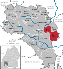
Location of Bad Dürrheim within Schwarzwald-Baar-Kreis district 
 | ||
| Coordinates: 48°01′N 08°32′E / 48.017°N 8.533°ECoordinates: 48°01′N 08°32′E / 48.017°N 8.533°E | ||
| Country | Germany | |
| State | Baden-Württemberg | |
| Admin. region | Freiburg | |
| District | Schwarzwald-Baar-Kreis | |
| Government | ||
| • Mayor | Walter Klumpp (FW) | |
| Area | ||
| • Total | 62.09 km2 (23.97 sq mi) | |
| Population (2013-12-31)[1] | ||
| • Total | 12,634 | |
| • Density | 200/km2 (530/sq mi) | |
| Time zone | CET/CEST (UTC+1/+2) | |
| Postal codes | 78073 | |
| Dialling codes | 07726 / 07706 | |
| Vehicle registration | VS | |
| Website | www.badduerrheim.de | |
Bad Dürrheim is a town in the district of Schwarzwald-Baar, in Baden-Württemberg, Germany. It is situated east of the Black Forest, 8 km north of Donaueschingen, and 6 km southeast of Villingen.
Bad Dürrheim was from 1951 until 1978 location of a broadcasting transmitter for mediumwave.
Twin towns — Sister cities
Bad Dürrheim is twinned with:
-
 Hajdúszoboszló, Hungary
 -
 Enghien-les-Bains, France
 -
 Spotorno, Italy
References
External links
| Wikimedia Commons has media related to Bad Dürrheim. |
- (German) Pictures Bad Dürrheim
- (German) Erster Farbfotos 1936 Farbdias
|
This article is issued from Wikipedia - version of the Monday, June 22, 2015. The text is available under the Creative Commons Attribution/Share Alike but additional terms may apply for the media files.
