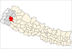
Babala
| Babala बबाला | |
|---|---|
| Village development committee | |
 Babala Location in Nepal | |
| Coordinates: 29°19′N 81°14′E / 29.32°N 81.24°ECoordinates: 29°19′N 81°14′E / 29.32°N 81.24°E | |
| Country |
|
| Zone | Seti Zone |
| District | Achham District |
| Population (1991) | |
| • Total | 2,623 |
| • Religions | Hindu |
| Time zone | Nepal Time (UTC+5:45) |
Babala is a village development committee in Achham District in the Seti Zone of western Nepal. According to the 1991 Nepal census it has a population of 2,623 and had 539 houses in the village[1] The population is entirely Hindu.
In 2001, 1252 people were illiterate, 252 male and 1001 female. In 2001, 805 in Babala were attending school, 459 male and 347 female.
In July 2003 the village was affected by landslides and resulted in an acute shortage of food. The flood displaced twelve families. The Nepal Red Cross Society (NRCS) was sent in to provided relief materials like food, clothes, utensils and cash. A flood victim in Babala reported to the Kathmandu Post "Everything including my house has been swept away by the landslides".
References
- ↑ "Nepal Census 2001". Nepal's Village Development Committees. Digital Himalaya. Retrieved 2008-08-10.
