Ciudad López Mateos
| Atizapán de Zaragoza | |
|---|---|
| Town & Municipality | |
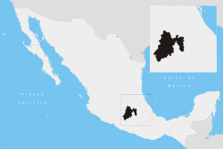
 Location of Atizapán de Zaragoza in the State of Mexico | |
| Coordinates: 19°33′40″N 99°14′49″W / 19.56111°N 99.24694°W | |
| Country |
|
| State |
|
| Region | Tlalnepantla |
| Metro area | Greater Mexico City |
| Municipal Status | September 3, 1874[1] |
| Municipal Seat | Ciudad López Mateos |
| Government | |
| • Type | Ayuntamiento |
| • Municipal President | Pedro David Rodríguez Villegas (2013-2015) |
| Area | |
| • Municipality | 91.07 km2 (35.16 sq mi) |
| • Water | 0.31 km2 (0.12 sq mi) |
| Elevation (of seat) | 2,280 m (7,480 ft) |
| Population (2010 Census) | |
| • Municipality | 489,937 |
| Time zone | CST (UTC-6) |
| • Summer (DST) | CDT (UTC-5) |
| Postal code (of seat) | 52975 |
| Area code(s) | 55 |
| Demonym | Atizapense |
| Website | Official website (Spanish) |
Ciudad López Mateos is a city in State of Mexico, Mexico, and the seat of the municipality called Atizapán de Zaragoza. It takes its name from the nahuatl word Ātīzapan, which is formed by three words: "ā-tl", which means "water", "tīza-tl", which means "white clay" and "īpan, which means "over" or "place over" in a metaphorical form. Finished this, the name means "Place over clay waters". Atizapán is located east from Toluca, and inside the Greater Mexico City limits.
The city
The city was previously named Atizapán de Zaragoza, but the official name was changed after president Adolfo López Mateos, who was born in that town. However, the city is still known as Atizapán. There were 471,904 inhabitants counted with the 2005 census. It is the seventh-largest city in the state. The city is the municipal seat of the municipality of Atizapán de Zaragoza, and for all practical purposes is coextensive with it.
During the French Intervention, general Ignacio Zaragoza stayed here, and used the town for the gathering of weapons.
This was the hometown of Mexican president Adolfo López Mateos, and a mausoleum was built for his remains in downtown Atizapán.
The municipality
While the city takes up almost all of the municipality, Ciudad López Mateos has governing jurisdiction over: Campos los Cedros, El Pedregal, Presa las Ruinas, Presa San Juan, Valle de Paz, Viejo Madín and Rancho Blanco Ejido de Espíritu Santo, the only one with any significant population at 501 people.
The municipality has an area of 89.9 km² (34.71 sq mi) and reported a population of 472,526. It lies in the northeastern part of the state, just northwest of the Federal District (Mexico City). This municipality is in the northwestern part of the state (in the metropolitan area of Mexico City). The municipality borders Naucalpan, Tlalnepantla de Baz, and Cuautitlán Izcalli.
In 1984, the city hall was transferred from downtown Atizapán, to a new building near the municipal limit with the municipality of Tlalnepantla de Baz.
From 1997 to 2009, Atizapán was under the government of the National Action Party.
Atizapán has several golf courses such as La Hacienda, Chiluca, Bellavista and Valle Escondido.
The Antonio Domínguez scandal
In 2000, Antonio Domínguez Zambrano was elected as the President of Atizapán, representing the National Action Party. After taking possession of the government was discovered that he was the head of many corruption and fraud events and also bullying rivals and fraud.
But the main charge was the murder of fellow party partner María de los Ángeles Tamez Reyes, which at the time was working as part of his government.
As a result, Antonio Domínguez was found guilty on all accounts and sent to prison with his secretary Daniel García.
Geography
Three rivers have their waterway across Atizapán: Tlalnepatla River, San Javier River and Moritas River, all of them located north of the municipality.
Inside Atizapán, near the border with Naucalpan, is located the Madin Dam, which provides water to the north west part of the Greater Mexico City area.
Also, various streams have their waterway across Atizapán such as "La Bolsa", La Herradura, "El Tecojote" and "El Xhinte".
Its main elevations are Biznaga Hill, Atlaco Hill La Condesa Hill and Grande Hill.
Transportation
Although none of the main transportation ways in greater Mexico City have stations in Atizapán, many bus lines cross Atizapán, and go mainly to the north, center and south west parts of Mexico City.
In the beginning of the 20th century, a train line called "Montealto" had its end in Atizapán.
In the north part of Atizapán is located an airport, which has minimal use, as no airlines are established.
Also, one highway passes across Atizapán, and serves to communicate Atizapán with the capital city of the State of Mexico Toluca, the Interlomas, Santa Fe and Herradura Boroughs, and with the Mexico-Querétaro highway.
Recently, the "Viaducto Bicentenario" has connected a second-floor highway to the inner Mexico City. The project was built to commemorate the bicentennial of Mexico's independence.
References
- ↑ "Enciclopedia de los Municipios y Delegaciones de México". Instituto Nacional para el Federalismo y el Desarrollo Municipal. Retrieved August 27, 2015.
- Link to tables of population data from Census of 2005 INEGI: Instituto Nacional de Estadística, Geografía e Informática
- México Enciclopedia de los Municipios de México
- Ciudadnorte, local newspaper and news agency of Atizapán
Coordinates: 19°33′N 99°17′W / 19.550°N 99.283°W
External links
- Ayuntamiento de Atizapán de Zaragoza Official website of the Municipality of Atizapán de Zaragoza
