Arroyo Seco bicycle path


The Arroyo Seco bicycle path is an approximately 2 miles (3.2 km) long Class I bicycle path in Los Angeles, California. The path connects Montecito Heights Recreation Center and Ernest E. Debs Regional Park in the Montecito Heights community, and Hermon Park in the Highland Park district, and runs parallel to State Route 110, and ends at Arroyo Seco Stables in South Pasadena.
Description
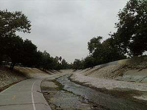
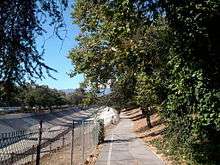
The Southwest portion of the path, approximately a quarter of a mile, runs along the higher ground overlooking Arroyo Seco through chain-link fence, and descends into the floor of Arroyo Seco flood control channel. Following the channel hydraulics, there is a very slight and mostly consistent uphill grade in the northeast direction with some stretches (notably under overpasses) with slightly greater slope.
In addition to north and south entrances, the path is accessible through a pedestrian bridge from Hermon Park. The path crosses several pedestrian and vehicular bridges along the way.
Closures
For safety reasons, if rain is predicted or if water release is expected from the upstream dam, public access is not permitted in the channel.
Connectivity
The path continues as an equestrian trail from its north terminus. Only horses and pedestrians are allowed beyond Arroyo Seco Stables. However, bicyclists can continue on Arroyo Blvd, a quiet residential street that extends towards Rose Bowl Stadium in Pasadena.
Los Angeles River and historic Chinatown are accessible through the industrial corridor from the path's south terminus.
Hazards
Especially after rain events, storm-borne debris accumulate on the path and pose danger to cyclist and pedestrians. Other hazards include trash and debris, such as beverage bottles, shopping carts, and electronics that are being illegally discarded into the channel from bridge overpasses. Due to periodical maintenance activities, the path is usually clear from any debris and provide enjoyable recreational area.
Ownership
Bike path is maintained by City of Los Angeles. The Arroyo Seco Channel that the bike path is located in is maintained by the Los Angeles County Department of Public Works.
See also
External links
Coordinates: 34°05′47″N 118°11′25″W / 34.0965°N 118.1903°W