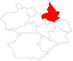
Arroio Grande, Santa Maria
For the district where is settled this bairro, see Arroio Grande, district of Santa Maria.
| Arroio Grande | |
|---|---|
| Bairro | |
 The bairro in District of Arroio Grande | |
 District of Arroio Grande, in Santa Maria City, Rio Grande do Sul, Brazil | |
| Coordinates: 29°40′09″S 53°39′47″W / 29.66917°S 53.66306°WCoordinates: 29°40′09″S 53°39′47″W / 29.66917°S 53.66306°W | |
| Country | Brazil |
| State | Rio Grande do Sul |
| Municipality/City | Santa Maria |
| District | District of Arroio Grande |
| Area | |
| • Total | 130.71 km2 (50.47 sq mi) |
| Population [1] | |
| • Total | 2,702 |
| • Density | 21/km2 (54/sq mi) |
| Adjacent bairros | Camobi, Km 3, Palma, Pé de Plátano |
| Website | Official site of Santa Maria |
Arroio Grande[2] ("big rivulet") is a bairro in the District of Arroio Grande in the municipality of Santa Maria, in the Brazilian state of Rio Grande do Sul. It is situated in northeast of Santa Maria.
Villages
The bairro contains the following villages: Arroio do Meio, Arroio Grande, Arroio Lobato, Cidade dos Meninos, Colônia Nova, Faxinal da Palma, Kipper, Linha Canudos, Noal, Nossa Senhora da Saúde, Rosalino Noal, São Marcos, São Valentin, Três Barras, Vila Arroio Grande, Vila Fighera, Vila Santa Brígida.
Gallery of photos
 |
Itaara | Itaara / Júlio de Castilhos | Silveira Martins |  |
| Itaara | |
Palma | ||
| ||||
| | ||||
| Km 3 | Pé de Plátano / Camobi | Pains |
References
This article is issued from Wikipedia - version of the Sunday, December 28, 2014. The text is available under the Creative Commons Attribution/Share Alike but additional terms may apply for the media files.
