Arkansas Highway 162
| ||||
|---|---|---|---|---|
 | ||||
| Route information | ||||
| Maintained by AHTD | ||||
| Section 1 | ||||
| Length: | 5.39 mi[1] (8.67 km) | |||
| West end: |
| |||
| East end: | Hobbtown Road | |||
| Section 2 | ||||
| Length: | 11.29 mi[1] (18.17 km) | |||
| West end: |
| |||
| East end: |
| |||
| Highway system | ||||
| ||||
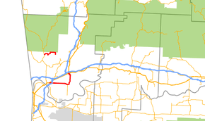
Arkansas Highway 162 (AR 162 and Hwy. 162) is the designation for two state highways in Crawford County, Arkansas.
Cedarville–Hobbtown segment
Arkansas Highway 162 is a state highway of 5.39 miles (8.67 km) in Crawford County.[2] It is designated Section 0 on the Crawford County State Highway Route and Section Map.[1]
AR 162 begins at AR 59 in Cedarville. The route heads east before ending and becoming Hobbtown Road.
Van Buren–Alma segment
Arkansas Highway 162 is a state highway of 11.29 miles (18.17 km) in Crawford County.[2] It is designated Section 1 on the Crawford County State Highway Route and Section Map.[1]
Route description
The route begins at US 64 in Alma and travels south then west through Kibler. AR 162 crosses under I-540/US 71 before ending at US 64 and US 71 Business in Van Buren.
Future Interchange
The highway is proposed to have a Interchange with Interstate 49
References
- 1 2 3 4 State Highway Route and Section Map - Crawford County, Arkansas (PDF) (Map). Arkansas State Highway and Transportation Department. May 29, 2012. Retrieved January 1, 2013.
- 1 2 Arkansas State Highway and Transportation Department. AHTD Crawford County map Retrieved on September 22, 2009.
