Arkansas Highway 142
| ||||
|---|---|---|---|---|
 | ||||
| Route information | ||||
| Maintained by AHTD | ||||
| Length: | 5.1 mi[1] (8.1 km) | |||
| Major junctions | ||||
| From: |
| |||
| To: | Levee Rd., Lakeport | |||
| Location | ||||
| Counties: | Chicot | |||
| Highway system | ||||
| ||||
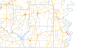
Arkansas Highway 142 is a state highway of 5.05 miles (8.13 km) in Arkansas.[1] It is a short route entirely in Chicot County.[2]
Route description
AR 143 begins at US 82/US 278 at Shives and runs south to terminate at Levee Rd. in Lakeport.
Major intersections
The entire route is in Chicot County.
| Location | mi[2] | km | Destinations | Notes | |
|---|---|---|---|---|---|
| Shives | 0.0 | 0.0 | northern terminus | ||
| Lakeport | 5.05 | 8.13 | CR 73 (Levee Rd.) | southern terminus | |
| 1.000 mi = 1.609 km; 1.000 km = 0.621 mi | |||||
History
AR 142 ran along Lake Chicot in 1935, but the route became US 82/US 278 before 1947.[3] The current routing was paved by 1962.[1] The route intersects the Fifth Principal Meridian.[3]
References
- 1 2 3 "[Arkansas] State Highways 2009 (Database)." April 2010. AHTD: Planning and Research Division. Database. Retrieved January 10, 2011.
- 1 2 General Highway Map - Chicot County, Arkansas (PDF) (Map) (2009 ed.). Arkansas State Highway and Transportation Department. Retrieved January 10, 2011.
- 1 2 Chicot County, Arkansas (Map) (1925, Revised 1935 ed.). Arkansas State Highway and Transportation Department. Retrieved January 10, 2011.
This article is issued from Wikipedia - version of the Tuesday, April 07, 2015. The text is available under the Creative Commons Attribution/Share Alike but additional terms may apply for the media files.
