Apopka, Florida
| Apopka, Florida | |||
|---|---|---|---|
| City | |||
| City of Apopka | |||
|
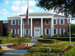
Apopka City Hall in April 2007 | |||
| |||
| Nickname(s): Indoor Foliage Capital of the World | |||
 Location in Orange County and the state of Florida | |||
| Coordinates: 28°42′6″N 81°31′57″W / 28.70167°N 81.53250°WCoordinates: 28°42′6″N 81°31′57″W / 28.70167°N 81.53250°W[1] | |||
| Country | United States | ||
| State | Florida | ||
| County | Orange | ||
| Incorporated | 1882 | ||
| Government | |||
| • Type | Mayor–council | ||
| • Mayor | Joe Kilsheimer (D) | ||
| Area[1] | |||
| • Total | 33.2 sq mi (86 km2) | ||
| • Land | 31.8 sq mi (82 km2) | ||
| • Water | 1.4 sq mi (4 km2) 4.07% | ||
| Elevation[2] | 131 ft (40 m) | ||
| Population (2010)[3] | |||
| • Total | 41,542 | ||
| • Density | 1,329.6/sq mi (513.4/km2) | ||
| Time zone | EST (UTC-5) | ||
| • Summer (DST) | EDT (UTC-4) | ||
| ZIP code(s) | 32703, 32712 | ||
| Area code(s) | 321, 407 | ||
| FIPS code | 12-01700[3] | ||
| GNIS feature ID | 0294327[2] | ||
| Website |
www | ||
Apopka is a city in Orange County, Florida. The city's population was 41,542 at the 2010 census,[4] up from 26,969 at the 2000 U.S. Census. It is part of the Orlando–Kissimmee–Sanford Metropolitan Statistical Area. Apopka is a Native American word for "Potato eating place".[5] Apopka is often referred to as the "Indoor Foliage Capital of the World".[6]
History
The earliest known inhabitants of the Apopka area were the Acuera people, members of the Timucua confederation. They had disappeared by 1730, probably decimated by diseases brought to Florida by Spanish colonists.
The Acuera were succeeded by refugees from Alabama and Georgia, who formed the new Seminole Indian tribe. They called the area Ahapopka. Aha, meaning "Potato," and papka, meaning "eating place". By the 1830s, this settlement numbered about 200, and was the birthplace of the chief Coacoochee (known in English as "Wild Cat").
At the conclusion of the Second Seminole War, the U.S. Congress passed the Armed Occupation Act of 1842, forcing surviving natives at Ahapopka to abandon their village and seek refuge deeper in the wilderness of the Florida peninsula.
The early American settlers built a major trading center on the foundations of the earlier Indian settlement. Their population was large enough by 1857 to support the establishment of a Masonic lodge. In 1859 the lodge erected a permanent meeting place at what is now the intersection of Main Street (U.S. Highway 441) and Alabama Avenue.
The Lodge
The settlers in the vicinity of "The Lodge" were largely isolated during the Civil War, but the area rebounded once peace was re-established, and a population boom followed the construction of railroad lines through the region.
In 1882 the one square mile surrounding "The Lodge" was officially incorporated under the name "Apopka".
In 1905, the Apopka City Council authorized incorporation of the Apopka Water, Light, and Ice Company. Councilman A.M. Starbird was appointed its manager, but it was not until voters approved a $9,000 bond in 1914 that he was able to contract with International Harvester Corporation to construct a power plant, so electricity was not available in the city until February 10, 1915. This independent utility company was one of many that were gobbled up by the Florida Public Service Corporation in the 1920s. They continued to manage the city's utility needs until the 1940s, when they sold off its ice plants to the Atlantic Company, its electric service to Florida Power Corporation, and its water services to Florida Utilities.
Historic buildings
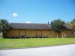
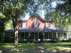
Five buildings in Apopka have been placed on the U.S. National Register of Historic Places through the Apopka Historical Society housed in the Museum of the Apopkans.
| Year Built | Building Name | Address | Image |
|---|---|---|---|
| 1885 | Apopka Seaboard Air Line Railway Depot | 36 E Station St |
 Apopka Seaboard Air Line Railway Depot |
| 1886 | Waite-Davis House | 5 S Central Ave |  Waite-Davis House |
| 1887 | Mitchell-Tibbetts House | 21 E Orange St |
 Mitchell-Tibbetts House |
| 1924 | Ryan & Company Lumber Yard | 215 E Fifth St |
 Ryan & Company Lumber Yard |
| 1932 | Carroll Building (Apopka, Florida) | 407-409 S Park Ave |
 Carroll Building |
Present-day Apopka
Apopka is known for having one of the longest-serving mayors in the United States. John H. Land, first elected in 1949, served for 61.25 years (with a short three-year gap), making him the longest serving mayor in Florida and longest serving full-time mayor in the United States through 2014.[7]

On April 8, 2014, Apopka City Commissioner Joe Kilsheimer won an election to succeed John H. Land as mayor.[8] Kilsheimer was sworn in on April 22, 2014.[9]
Mayors
| Apopka Mayor | First Year | Total Years | Total Years | Apopka Mayor | Multi-Year Terms January 1 | December 31 | Years | Total Years |
|---|---|---|---|---|---|---|---|---|
| J. D. Fudge | 1882 | 3 | John Jewell | 1926 | 1930 | 5 | ||
| J. J. Combs | 1885 | 1 | E. J. Ryan | 1931 | 1934 | 3 | ||
| Page McKinney | 1886 | 2 | Gillen McClure | 1935 | 1937 | 3 | ||
| Horatio Brewer | 1888 | 5 | Mark V. Ryan | 1938 | 1940 | 3 | ||
| R. C. Waters | 1893 | 2 | Leslie P. Waite | 1941 | 1946 | 6 | ||
| E. A. Jackson | 1895 | 1 | Dr. C.[10] H. Damsel | 1947 | 1949 | 3 | ||
| A. J. Lovell | 1896 | 9 | * | John H. Land | 1950 | 1967 | 18 | * |
| Joseph D Mitchill | 1905 | 7 | * | Leonard Hurst | 1968 | 1970 | 3 | |
| A. M. Starbird | 1912 | 1 | John H. Land | 1971 | 2014 March | 43.25 | 61.25 | |
| A. J. Lovell | 1913 | 1 | 10 | Joe Kilsheimer | 2014 April | |||
| W. R. McLeod | 1914 | 1 | ||||||
| Frank Davis | 1915 | 1 | ||||||
| Walter Newell | 1916 | 2 | * | |||||
| T. B. Tower | 1918 | 1 | ||||||
| W. P. Newell | 1919 | 1 | 3 | |||||
| Joseph D Mitchill | 1920 | 3 | 10 | |||||
| E. B. Morre | 1923 | 3 |
Development
Apopka is a fast-growing city and is expanding in all directions. Most notable are the new Lowes and Home Depot DIY stores to the north of the city on US 441 in the location of the previous Dunn Citrus grove (the stretch of 441 which runs through the city is named after Fred N. Dunn). Other businesses on the former Dunn Citrus site include Staples office supply and a second Chili's restaurant.
The John Land Apopka Expressway (Toll 414) opened on May 15, 2009,[11] relieving some of US 441's traffic, taking the route from what is now the US 441 junction with SR 429, and then passing south of the city to rejoin US 441 at its junction with Maitland Boulevard South of the city.
Earthmoving began in the summer of 2010 to further expand the expressway, including an extension of Toll 414, known as Wekiva Parkway, created a junction at US 441 and Plymouth Sorrento Road. Master plans take the Wekiva Parkway extension further north and then east connecting to Interstate 4 at Sanford. The expansion is scheduled to be completed in the next several years. It will then be the shortest route from I-4 to the Disney attractions.
Forbes Magazine named Apopka the "14th Friendliest City in America" in December 2012.[12]
Geography
Apopka is located at 28°40′34″N 81°30′38″W / 28.676075°N 81.510618°W.[1] It is about 16 miles northwest of Downtown Orlando.
According to the United States Census Bureau, the city has a total area of 32.6 square miles (84.4 km2). 31.2 square miles (80.9 km2) of it is land and 1.4 square miles (3.5 km2) of it (4.15%) is water.[13]
Climate
| Climate data for Plymouth 3N, 2002-2015 normals, extremes 2002-present | |||||||||||||
|---|---|---|---|---|---|---|---|---|---|---|---|---|---|
| Month | Jan | Feb | Mar | Apr | May | Jun | Jul | Aug | Sep | Oct | Nov | Dec | Year |
| Record high °F (°C) | 86 (30) |
88 (31) |
92 (33) |
96 (36) |
98 (37) |
100 (38) |
98 (37) |
99 (37) |
97 (36) |
96 (36) |
91 (33) |
87 (31) |
100 (38) |
| Average high °F (°C) | 70.2 (21.2) |
72.1 (22.3) |
78.5 (25.8) |
83.4 (28.6) |
88.6 (31.4) |
90.9 (32.7) |
92.0 (33.3) |
92.2 (33.4) |
89.8 (32.1) |
84.8 (29.3) |
76.9 (24.9) |
72.0 (22.2) |
82.6 (28.1) |
| Average low °F (°C) | 41.8 (5.4) |
44.3 (6.8) |
50.0 (10) |
54.8 (12.7) |
62.5 (16.9) |
69.6 (20.9) |
71.7 (22.1) |
72.3 (22.4) |
69.5 (20.8) |
60.9 (16.1) |
51.1 (10.6) |
45.4 (7.4) |
57.8 (14.3) |
| Record low °F (°C) | 16 (−9) |
19 (−7) |
26 (−3) |
30 (−1) |
45 (7) |
57 (14) |
65 (18) |
63 (17) |
54 (12) |
32 (0) |
28 (−2) |
15 (−9) |
15 (−9) |
| Average precipitation inches (mm) | 2.51 (63.8) |
2.56 (65) |
3.01 (76.5) |
3.02 (76.7) |
4.03 (102.4) |
7.95 (201.9) |
7.15 (181.6) |
8.36 (212.3) |
4.75 (120.7) |
2.80 (71.1) |
1.47 (37.3) |
2.71 (68.8) |
50.32 (1,278.1) |
| Average rainy days (≥ 0.01 in) | 7.2 | 6.9 | 6.9 | 5.1 | 7.8 | 16.0 | 16.5 | 17.8 | 11.9 | 7.3 | 4.5 | 7.0 | 114.9 |
| Source: NOAA[14] | |||||||||||||
Demographics
| Historical population | |||
|---|---|---|---|
| Census | Pop. | %± | |
| 1890 | 490 | — | |
| 1900 | 218 | −55.5% | |
| 1910 | 410 | 88.1% | |
| 1920 | 798 | 94.6% | |
| 1930 | 1,134 | 42.1% | |
| 1940 | 1,312 | 15.7% | |
| 1950 | 2,254 | 71.8% | |
| 1960 | 3,578 | 58.7% | |
| 1970 | 4,045 | 13.1% | |
| 1980 | 6,019 | 48.8% | |
| 1990 | 13,512 | 124.5% | |
| 2000 | 26,642 | 97.2% | |
| 2010 | 41,542 | 55.9% | |
| Est. 2014 | 47,084 | [15] | 13.3% |
As of the census of 2000, there were 26,642 people, 9,562 households, and 7,171 families residing in the city. The population density was 1,108.1 inhabitants per square mile (427.9/km²). There were 10,091 housing units at an average density of 419.7 per square mile (162.1/km²). The racial makeup of the city was 73.85% White, 15.56% African American, 0.42% Native American, 1.89% Asian, 0.09% Pacific Islander, 5.36% from other races, and 2.83% from two or more races. Hispanic or Latino of any race were 18.08% of the population.
There were 9,562 households out of which 38.2% had children under the age of 18 living with them, 55.8% were married couples living together, 14.4% had a female householder with no husband present, and 25.0% were non-families. 18.6% of all households were made up of individuals and 5.8% had someone living alone who was 65 years of age or older. The average household size was 2.76 and the average family size was 3.13.
In the city the population was spread out with 28.2% under the age of 18, 8.6% from 18 to 24, 33.6% from 25 to 44, 19.5% from 45 to 64, and 10.1% who were 65 years of age or older. The median age was 33 years. For every 100 females there were 94.0 males. For every 100 females age 18 and over, there were 90.1 males.
The median income for a household in the city was $43,651, and the median income for a family was $49,380. Males had a median income of $32,177 versus $26,553 for females. The per capita income for the city was $19,189. About 7.1% of families and 9.5% of the population were below the poverty line, including 12.6% of those under age 18 and 9.7% of those age 65 or over.
In 2010 Apopka had a population of 41,542. The racial and ethnic composition of the population was 49.5% White, 20.7% African American, 0.3% Native American, 3.2% Asian, 0.1% Pacific Islander, 0.4% non-Hispanic reporting some other race, 3.3% reporting two or more races and 25.4% Hispanic or Latino.[17]
Education
- Apopka is served by Orange County Public Schools with two high schools: Apopka High School and Wekiva High School.
- University of Florida's Institute of Food and Agricultural Sciences Mid-Florida Research and Education Center is located in Apopka.
Notable people
- John Anderson, country singer
- Steve Baylark, NFL running back
- Rogers Beckett, former NFL safety
- Richard Borg, board game designer
- Sawyer Brown, country music band founded in Apopka
- Alan Gendreau, football place kicker at Middle Tennessee State
- Zack Greinke, pitcher for Los Angeles Dodgers and 2009 AL Cy Young Award winner
- Glenn Hubbard, dean, Columbia University Graduate School of Business
- Michael Larson, Press Your Luck Scandal winner of $110,237 in 1984
- Jerry Lawson, former lead singer of The Persuasions
- Brandon Meriweather, former University of Miami All-American safety and presently a defensive back for the Washington Redskins
- Fireball Roberts, race car driver
- Warren Sapp, All-Pro NFL defensive lineman
- Sammie Smith, former NFL running back who played for the Miami Dolphins and Denver Broncos
- Monty Sopp, professional wrestler, former WWF/E World Tag Team, Intercontinental, and Hardcore champion
- Wayne Taylor, owner, Wayne Taylor Racing. Winner of 1996 and 2005 24 Hours of Daytona, and the 2005 Rolex Series.
- Tom Terry, Chief Meteorologist at WFTV in Orlando
Apopka in literature
Apopka is referenced in Zora Neale Hurston's famous novel, Their Eyes Were Watching God.
Apopka is referenced in Eddie C. Brown's autobiographical book, Beating the Odds: Eddie Brown's Investing and Life Strategies.
References
- 1 2 3 "US Gazetteer files: 2010, 2000, and 1990". United States Census Bureau. 2011-02-12. Retrieved 2011-04-23.
- 1 2 "US Board on Geographic Names". United States Geological Survey. 2007-10-25. Retrieved 2008-01-31.
- 1 2 "American FactFinder". United States Census Bureau. Retrieved 2015-04-26.
- ↑ "Profile of General Population and Housing Characteristics: 2010 Demographic Profile Data (DP-1): Apopka city, Florida". U.S. Census Bureau, American Factfinder. Retrieved September 20, 2012.
- ↑ "Seminole Tribe of Florida - Culture, Language". Semtribe.com. Retrieved 2012-12-18.
- ↑ "City of Apopka - Home". Apopka.net. 2006-07-01. Retrieved 2012-12-18.
- ↑ McKay, Rich (2010-01-01). "Land returned as mayor as election qualifying ends - Orlando Sentinel". Articles.orlandosentinel.com. Retrieved 2012-12-18.
- ↑ First elected in 1949, 93-year-old Apopka mayor loses historic vote
- ↑ Apopka's new mayor seeks to build around city's 'inner Mayberry'
- ↑ His grandson (me)
- ↑ "Orlando toller completes FL414 Apopka pike - opening ceremony". TOLLROADSnews. Retrieved 2012-12-18.
- ↑ http://www.forbes.com/sites/morganbrennan/2012/12/19/americas-friendliest-towns/
- ↑ "Geographic Identifiers: 2010 Demographic Profile Data (G001): Apopka city, Florida". U.S. Census Bureau, American Factfinder. Retrieved September 20, 2012.
- ↑ "NOWData - NOAA Online Weather Data". National Oceanic and Atmospheric Administration. Retrieved November 12, 2015.
- ↑ "Annual Estimates of the Resident Population for Incorporated Places: April 1, 2010 to July 1, 2014". Retrieved June 4, 2015.
- ↑ "Census of Population and Housing". Census.gov. Retrieved June 4, 2015.
- ↑ 2010 population report for Apopka
External links
- Official website
- Apopka Chief, local newspaper, available for free in full-text with images in the Florida Digital Newspaper Library
| Wikimedia Commons has media related to Apopka, Florida. |
| |||||||||||||||||||||||||||||


