Anzoátegui
| Anzoátegui | |||
|---|---|---|---|
| State of Venezuela | |||
|
| |||
| |||
|
Motto: Tumba de sus tiranos (English: Tomb of its tyrants) | |||
| Anthem: Himno del Estado Anzoátegui | |||
 Location within Venezuela | |||
| Country | Venezuela | ||
| Created | 1909 | ||
| Capital | Barcelona | ||
| Government | |||
| • Governor | Nelson Moreno (2016) | ||
| Area | |||
| • Total | 43,300 km2 (16,700 sq mi) | ||
| Area rank | 6th | ||
| 4.72% of Venezuela | |||
| Population (2011 est.) | |||
| • Total | 1,469,747 | ||
| • Rank | 8th | ||
| 5.3% of Venezuela | |||
| Time zone | UTC-04:30 | ||
| ISO 3166 code | VE-B | ||
| Emblematic tree | Cereipo, or Guatamare (Myrospermum fructescens) | ||
| Website |
www | ||
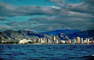
Anzoátegui State (Spanish: Estado Anzoátegui, IPA: [esˈtaðo ansoˈateɣi]), is one of the 23 component states of Venezuela, located in the northeastern region of the country. Anzoátegui is well known for its beaches that attract many visitors. Its coast consists of a single beach approximately 100 km long. Its capital is the city of Barcelona, and significant cities include Puerto la Cruz and El Tigre.
History
Named after the great hero of Venezuelan independence, José Antonio Anzoátegui (1789–1819), this state has its own history. The city of Barcelona, which is currently the state's capital, was founded in 1677. The present Anzoátegui State was included within the Cumaná Province, which was itself part of the Captaincy General of Venezuela, along with some other provinces (Guayana, Maracaibo, Caracas, Margarita and Trinidad). In 1810, it was separated from the province. It was in 1909 that it acquired the present political distribution.
Geography
Anzoátegui is located in the northeastern region of the country and is bordered by the states of Monagas and Sucre to the east, Bolivar to the south, Guarico to the west, Miranda to the northwest, and the Caribbean Sea to the north.
Population
Based on the 2001 census information, the estimated population of Anzoátegui State in 2007 is 1,477,900 inhabitants.
Economy
Anzoátegui's economy is dominated by Venezuela's principal resource: oil. It houses the "Complejo Petroquímico de Jose", one of the biggest petrochemical facilities in Latin America. However, Anzoátegui also has thriving fishing and tourism industries.
Municipalities and municipal seats
Anzoátegui comprises 21 municipalities (municipios), listed below:
- Anaco (Anaco)
- Aragua (Aragua de Barcelona)
- Diego Bautista Urbaneja (Lechería)
- Fernando de Peñalver (Puerto Píritu)
- Francisco de Carmen Carvajal (Valle de Guanape)
- Francisco de Miranda (Pariaguán)
- Guanta (Guanta)
- Independencia (Soledad)
- José Gregorio Monagas (Mapire)
- Juan Antonio Sotillo (Puerto la Cruz)
- Juan Manuel Cajigal (Onoto)
- Libertad (San Mateo)
- Manuel Ezequiel Bruzual (Clarines)
- Pedro María Freites (Cantaura)
- Píritu (Píritu)
- San José de Guanipa (San José de Guanipa/El Tigrito)
- San Juan de Capistrano (Boca de Uchire)
- Santa Ana (Santa Ana)
- Simón Bolívar (Barcelona)
- Simón Rodríguez (El Tigre)
- Sir Arthur McGregor (El Chaparro)
Population
Race and ethnicity
According to the 2011 Census, the racial composition of the population was:[1]
| Racial composition | Population | % |
|---|---|---|
| Mestizo | N/A | 54.9 |
| White | 629,802 | 40.0 |
| Black | 61,406 | 3.9 |
| Other race | N/A | 1.2 |
See also
References
- ↑ "Resultado Básico del XIV Censo Nacional de Población y Vivienda 2011 (Mayo 2014)" (PDF). Ine.gov.ve. p. 29. Retrieved 8 September 2015.
External links
| Wikimedia Commons has media related to Anzoátegui. |
| ||||||||||||||||||||||||
Coordinates: 10°4′N 64°43′W / 10.067°N 64.717°W


