Anta Province
| Anta | |
|---|---|
| Province | |
|
The archaeological site of Tarawasi in the Anta Province | |
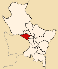
 Location of Anta in the Cusco Region | |
| Country | Peru |
| Region | Cusco |
| Capital | Anta |
| Government | |
| • Mayor | Wilbert Gabrwilbert Gabriel Rozas Beltran (2007) |
| Area | |
| • Total | 1,876.12 km2 (724.37 sq mi) |
| Population (2005 census) | |
| • Total | 57,905 |
| • Density | 31/km2 (80/sq mi) |
| UBIGEO | 0803 |
| Website |
www |
Anta Province is one of thirteen provinces in the Cusco Region in the southern highlands of Peru.
Geography
The Willkapampa mountain range traverses the province. The highest peak of the province is Sallqantay at 6,271 metres (20,574 ft). Other mountains are listed below:[1]
|
Political division
The province is divided into nine districts (Spanish: distritos, singular: distrito), each of which is headed by a mayor (alcalde). The districts, with their capitals in parenthesis, are:
- Ancahuasi (Ancahuasi)
- Anta (Anta)
- Cachimayo (Cachimayo)
- Chinchaypujio (Chinchaypujio)
- Huarocondo (Huarocondo)
- Limatambo (Limatambo)
- Mollepata (Mollepata)
- Pucyura (Pucyura)
- Zurite (Zurite)
Ethnic groups
The people in the province are mainly indigenous citizens of Quechua descent. Quechua is the language which the majority of the population (70.28%) learnt to speak in childhood, 29.35% of the residents started speaking in Spanish.[2]
See also
Sources
- ↑ escale.minedu.gob.pe - UGEL map of the Anta Province (Cusco Region)
- ↑ inei.gob.pe INEI, Peru, Censos Nacionales 2007
| ||||||
Coordinates: 13°28′49″S 72°06′40″W / 13.480167°S 72.111245°W
This article is issued from Wikipedia - version of the Saturday, December 19, 2015. The text is available under the Creative Commons Attribution/Share Alike but additional terms may apply for the media files.

