Palace of Nestor
Coordinates: 37°1′37.37″N 21°41′41.41″E / 37.0270472°N 21.6948361°E The so-called Palace of Nestor (Modern Greek: Ἀνάκτορον Νέστορος[1] (Kath.), Ανάκτορο του Νέστορα (Dim.)) is the primary structure within a larger Late Helladic era settlement, likely once surrounded by a fortified wall. The palace, widely identified with that of Mycenaean-era Pylos, was a two-storey building with store rooms, workshops, baths, light wells, reception rooms and a sewage system. The site is the best preserved Mycenaean Greek palace discovered.
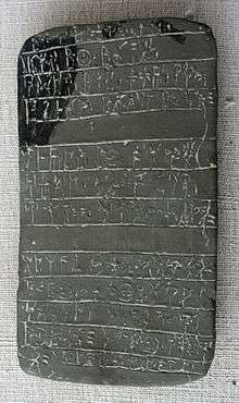
During excavation in 1939 around 1,000 Linear B tablets were identified.
The settlement had been long occupied with most artefacts discovered dating from 1300 BCE. The palace complex was destroyed by fire around 1200 BCE.
In May 2013 the site was closed for renovation. The 1960s roof over the site is being replaced by a modern structure. It may re-open at the end of 2014.[2][3]
Location
The site is on the hill of Epano Englianos, situated close to the road 4 kilometres (2.5 mi) south of Chora and 17 kilometres (11 mi) north of Pylos. The Palace is at the top of the hill at 150 metres (490 ft) above sea level and in an area of 170 metres (560 ft) by 90 metres (300 ft).

Excavations


In 1912 and 1926 two tholos tombs north of the Bay of Navarino were excavated. One contained three decorated jars and the other a collection of Early Mycenaean and Middle Helladic pots. A joint Hellenic-American expedition was formed with the Greek Archaeological Service and the University of Cincinnati.[4]
Trial excavations of Epano Englianos were started on 4 April 1939. From the first day stone walls, fresco fragments, Mycenaean pottery and inscribed tablets were found. More than 600 Linear B script tablets were recovered in the first season of excavations. A systematic excavation was impossible throughout World War II, with excavations restarting in 1952.[5]
From 1952 to 1966 the Palace was uncovered with areas around the acropolis being further explored. In the winter of 1960-61 the Greek Archaeological Service erected the protective metal roof over the central building.[6]
Tablets
The Linear B clay tablets confirm that the palace served as the administrative, political and financial centre of Mycenaean Messenia.
See also
- Enkheljāwōn, a person whom modern scholars regard as a possible king of Mycenaean Pylos
Notes
- ↑ Archaiologikon deltion, Volume 19, Part 2, Issues 1–2, Athens: "Hestia" Printing House, 1966, p. 150.
- ↑ www.archaiologia.gr.
- ↑ Athens Macedonian News Agency.
- ↑ (Blegen et al. 2001, p. 3)
- ↑ (Blegen et al. 2001, p. 4)
- ↑ (Blegen et al. 2001, p. 5)
Sources
- Blegen, Carl William; Rawson, Marion; Davis, Jack L.; Shelmerdine, Cynthia W. (2001), A Guide to the Palace of Nestor, Mycenaean Sites in its Environs and the Chora Museum (2 ed.), ASCSA, ISBN 9780876616406
- Blegen, Carl William; Rawson, Marion; Lang, Mabel (1966–1973), The Palace of Nestor at Pylos in western Messenia, Princeton University Press for the University of Cincinnati. OCLC Number 512087
- v. 1. The buildings and their contents, by C. W. Blegen and M. Rawson. pt. 1. Text. pt. 2. Illustrations.
- v. 2. The frescoes, by M. L. Lang.
- v. 3. Acropolis and lower town: tholoi, grave circle, and chamber tombs; discoveries outside the citadel, by C. W. Blegen and others.
External links
- Pylos Project, University of Minnesota
- Garland, Robert (2008), Daily life of the ancient Greeks (2 ed.), ABC-CLIO, ISBN 9780313358142