Anderson Canyon
| Anderson Canyon (Anderson Creek) | |
| Pino Pelado Creek | |
| Creek | |
 Anderson Canyon (present day view from Julia Pfeiffer Burns State Park) | |
| Country | United States |
|---|---|
| State | California |
| City | Big Sur |
| Source | |
| - location | Coast Range, Anderson Peak (Sierra Nevada), California |
| - elevation | 3,000 ft (914 m) |
| Mouth | Pacific Ocean |
| - location | Anderson Canyon mouth, California |
| - elevation | 0 ft (0 m) |
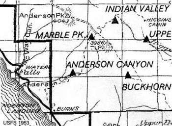
The Anderson Canyon region of Big Sur, California, also known as Anderson Creek, is a historically notable part of the Big Sur coast. It is located directly south of the Julia Pfeiffer Burns State Park and was home to a Highway One work camp as well as the Anderson Creek Gang which consisted of bohemians including Henry Miller and Jean Varda.
The region is located within the Monterey Bay National Marine Sanctuary, Sea Otter Refuge, and California condor reintroduction area. The region is privately owned and completely surrounded by Julia Pfeiffer Burns State Park. It is the next creek south from McWay Creek's famed waterfall cove and contains numerous falls on private property.
Anderson Peak, at the top of Anderson Canyon, rises to 4099 feet.[1] The ocean-facing bluff at the mouth of Anderson Canyon sits 120 feet above sea level.
Early history

The Anderson Canyon area has played an important part of the history of the Big Sur region. In the late 19th century there was a trail connecting the coast ridge at Marble Peak with the coast at Burns Creek, just south of the Anderson Landing site, known as the Anderson Canyon trail. Anderson Creek was first called Pino Pelado Creek, and Anderson Peak known as Pino Pelado Peak. The name Anderson Canyon and Anderson Creek emerged after the early settlers James and Peter Andersen who settled the area as early as 1874.[2]
Prior to the construction of Highway One, this area was the center of economic activity for the region with families harvesting redwood, tanbark, limestone, and gold. These resources were shipped out of dog-hole ports located in the region including Anderson Landing.[3]
The port located at the mouth of Anderson Creek was known as Saddle Rock Landing. It was named for its proximity (.4 miles) to Saddle Rock which is a prominent feature at the Julia Pfeiffer Burns State Park.[4]
The Anderson Canyon region was homestead by Aaron Harlan, located about a mile up the canyon from the mouth of the creek. "Pop" Ernest Doelter, a Monterey, CA restaurateur who created the abalone steak, owned the Saddle Rock Landing for abalone harvesting. Pop's restaurant was a favorite of George Sterling, Jack London, and Andrew Molera.[5]
Highway construction
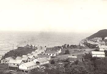
During the construction of Highway One, Anderson canyon hosted one of the largest labor camps on the coast. This camp was established in 1932.[6] During the late 1920s and early 1930s, the construction of the Highway was temporarily suspended and Anderson Canyon was the South end of the road.[7][8]

The 10 mile section of Highway One between Anderson Canyon and Big Sur was completed in October, 1924. From the Anderson Canyon camp, the Highway was built south to Big Creek.[9]
Anderson Canyon was the last of such labor camps.[10]
Bohemians
After the Highway was complete, many buildings were left standing on the site from its use as a convict camp. During the 1940 and early 1950s, these cabins were rented out to early Bohemians. Other avant-garde artists who lived here include Harry Partch, Emil White, and Jean Varda. Author Elizabeth Smart also lived at Anderson Canyon. Her novella, By Grand Central Station I Sat Down and Wept (1945) may be the first fiction regarding Big Sur's bohemia.
Henry Miller lived here from 1944 to 1947.[11] This is where he wrote "Into the Nightlife", and he discusses his time here and the Anderson Creek Gang in Big Sur and the Oranges of Hieronymus Bosch.[12] Miller reportedly paid $5 per month rent for his shack on the property.[13]
Architecture
In 1967 ground broke for a new house on the property designed by noted architect George-Brook Kothlow. The new owners of the property were Tony and Marguerite Staude, famed designer and financiers of the Chapel of the Holy Cross in Sedona, Arizona.
Ecology and biology
Anderson Peak is home to a California condor release site, owned by the Ventana Wildlife Society at 2770 feet.[14] In 2006, Anderson Canyon became the location of the first natural condor nesting site in California since 1905. Two condors were discovered in a hollowed out, partially burned redwood tree.[15][16]
In 2011, PG&E began a $4.2 million project to bury power lines running from Highway One up Anderson Canyon to Anderson Peak in order to protect condors from potential electrocution. The project involved around 3 miles of overhead power lines, built in the 1950s, to be removed and installation of an underground replacement line traveling 4,000 feet high.[17]
Anderson Canyon is an upland redwood forest. Characteristic species include coastal redwood, California bay, tanbark oak, big-leaf maple, and western sword fern. Wildlife species that may occur in this community include ensatina, Pacific slender salamander, Pacific giant salamander, western-screech owl, Allen’s hummingbird, purple martin, acorn woodpecker, Steller’s jay, Townsend’s western big-eared bat, and pallid bat.[18]
Film credits
Anderson Canyon appears in many films and photoshoots including National Geographic's Big Sur: Wild California, the Richard Burton and Liz Taylor classic The Sandpiper, and more recently in a feature film based on Jack Kerouac's Big Sur.[19] Anderson Canyon also stands in for the Esalen Institute setting in the series finale of the television show Mad Men.[20]
See also
- List of rivers in California
- Carmel Bay State Marine Conservation Area
- Big Sur River
- Little Sur River
- Geography of California
- Notleys Landing, California
- Lucia, California
References
- ↑ Jeff Norman, A Brief History of the Anderson Canyon Area, in the Big Sur Historical Society Newsletter, Issue 51, Summer 1997
- ↑ Double Cone Quarterly, 1998
- ↑ Double Cone Quarterly, 1998
- ↑ Jeff Norman, A Brief History of the Anderson Canyon Area, in the Big Sur Historical Society Newsletter, Issue 51, Summer 1997
- ↑ Jeff Norman, A Brief History of the Anderson Canyon Area, in the Big Sur Historical Society Newsletter, Issue 51, Summer 1997
- ↑ Double Cone Quarterly, 1998
- ↑ Jeff Norman, A Brief History of the Anderson Canyon Area, in the Big Sur Historical Society Newsletter, Issue 51, Summer 1997
- ↑ Historic Resource Evaluation Report on the Rock Retaining Walls, Parapets, Culvert: Headwalls and Drinking Fountains along the Carmel to San Simeon Highway. Caltrans, November 1996
- ↑ THE CAMBRIA HISTORY EXCHANGE
- ↑ Jeff Norman, Big Sur Historical Society
- ↑ Jeff Norman, A Brief History of the Anderson Canyon Area, in the Big Sur Historical Society Newsletter, Issue 51, Summer 1997
- ↑ Henry Miller Memorial Library
- ↑ PingPong, 2008
- ↑ Audubon.org
- ↑ National Geographic
- ↑ Ventana Wildlife Society Youtube
- ↑ PG&E
- ↑ California Coastal Commission
- ↑ Cinematography.com
- ↑
External links
- Big Sur and the Oranges of Hieronymus Bosch
- Anderson Canyon Website
- Photos of Henry Miller at Anderson Canyon
- GNIS Detail:Anderson Canyon
- GNIS Detail: Anderson Creek
- Elmer Staude Obituary
Coordinates: 36°09′24″N 121°39′55″W / 36.1567°N 121.6652°W