An t-Iasgair

An Dubh Sgeir, An t-lasgair, and Sgeir nan Ruideag
An t-Iasgair (Scottish Gaelic for the Fisherman) is a skerry in the Little Minch, to the north of the Trotternish peninsula of Skye. It lies 1.5 miles north north west of Ru Bornesketaig and is marked by a navigation light.[1] It is the largest and highest in a group of three rocks, with smaller neighbours of Sgeir nan Ruideag and An Dubh Sgeir.
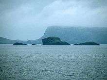
Sgeir nan Ruideag, An t-Iasgair and An Dubh Sgeir
| Location | Skye |
|---|---|
| Coordinates | 57°41.112′N 6°26.009′W / 57.685200°N 6.433483°WCoordinates: 57°41.112′N 6°26.009′W / 57.685200°N 6.433483°W |
| Construction | Framework Structure |
| Focal height | 23 metres (75 ft) |
| Range | 9 nautical miles |
| Characteristic | Fl. W 6sec |
Footnotes
- ↑ "An-T-Iasgair". Northern Lighthouse Board. Retrieved 16 January 2011.
| ||||||||||||||||||||||
This article is issued from Wikipedia - version of the Monday, September 14, 2015. The text is available under the Creative Commons Attribution/Share Alike but additional terms may apply for the media files.