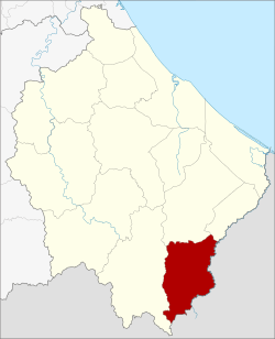
Waeng District
| Waeng แว้ง | |
|---|---|
| Amphoe | |
 Amphoe location in Narathiwat Province | |
| Coordinates: 5°55′41″N 101°53′2″E / 5.92806°N 101.88389°ECoordinates: 5°55′41″N 101°53′2″E / 5.92806°N 101.88389°E | |
| Country |
|
| Province | Narathiwat |
| Seat | Waeng |
| Area | |
| • Total | 347.3 km2 (134.1 sq mi) |
| Population (2005) | |
| • Total | 47,314 |
| • Density | 136.2/km2 (353/sq mi) |
| Time zone | THA (UTC+7) |
| Postal code | 96160 |
| Geocode | 9608 |
Waeng (Thai: แว้ง) is the southernmost district (amphoe) of Narathiwat Province, southern Thailand.
History
The district goes back to the district Tomo (โต๊ะโมะ), which was a subordinate of Mueang Ra-ngae. The village grew bigger and bigger because of the gold mining there. 1935 a minor district (king amphoe) covering the central part of Tomo was established and named Pa Cho (ปาโจ).[1] 1939 the minor district received the name Tomo because it contained the subdistrict named Tomo, and the parent district was renamed to Waeng.[2] 1953 the minor district Tomo was abolished and included into Waeng again.[3] 1957 the subdistrict Tomo was also abolished and included into the subdistrict Samong,[4] which then formed part of area split off as minor district Sukhirin in 1977.
Geography
Neighboring districts are (from the west clockwise) Sukhirin, Su-ngai Padi and Su-ngai Kolok. To the south is the Kelantan state of Malaysia.
At the village of Ban Buketa, a Malaysia-Thailand border border crossing to the neighboring Malaysian town of Bukit Bunga.[5] A part of Hala-Bala wildlife sanctuary is located in the district.
Administration
The district is subdivided into 6 subdistricts (tambon), which are further subdivided into 45 villages (muban). There are two townships (thesaban tambon) within the district - Waeng covers parts of the tambon Waeng, and Buketa covers parts of tambon Lochut.
| No. | Name | Thai name | Villages | Inh. | |
|---|---|---|---|---|---|
| 1. | Waeng | แว้ง | 7 | 12465 | |
| 2. | Kayu Khla | กายูคละ | 9 | 7308 | |
| 3. | Kholo | ฆอเลาะ | 7 | 6700 | |
| 4. | Lochut | โละจูด | 8 | 10677 | |
| 5. | Mae Dong | แม่ดง | 7 | 6009 | |
| 6. | Erawan | เอราวัณ | 7 | 4155 |
References
- ↑ ประกาศกระทรวงมหาดไทย เรื่อง ตั้งกิ่งอำเภอปาโจ (PDF). Royal Gazette (in Thai) 52 (0 ง): 2501. November 17, 1935.
- ↑ พระราชกฤษฎีกาเปลี่ยนนามอำเภอ กิ่งอำเภอ และตำบลบางแห่ง พุทธศักราช ๒๔๘๒ (PDF). Royal Gazette (in Thai) 56 (0 ก): 354–364. April 17, 1939.
- ↑ ประกาศกระทรวงมหาดไทย เรื่อง ยุบกิ่งอำเภอโต๊ะโมะ อำเภอแว้ง จังหวัดนราธิวาส (PDF). Royal Gazette (in Thai) 70 (56 ง): 3062. September 1, 1953.
- ↑ ประกาศกระทรวงมหาดไทย เรื่อง ยุบและเปลี่ยนแปลงเขตตำบลในท้องที่อำเภอแว้ง จังหวัดนราธิวาส (PDF). Royal Gazette (in Thai) 74 (25 ง): 679. March 12, 1957.
- ↑ Official Website for Ministry of Foreign Affairs, Malaysia
External links
| ||||||