Amnat Charoen Province
| Amnat Charoen อำนาจเจริญ | |
|---|---|
| Province | |
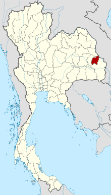
 Map of Thailand highlighting Amnat Charoen Province | |
| Country |
|
| Capital | Amnat Charoen |
| Government | |
| • Governor | Bunsanong Bunmi (since March 2009) |
| Area | |
| • Total | 3,161.2 km2 (1,220.5 sq mi) |
| Area rank | Ranked 60th |
| Population (2014) | |
| • Total | 375,380[1] |
| • Rank | Ranked 63rd |
| • Density rank | Ranked 40th |
| Time zone | ICT (UTC+7) |
| ISO 3166 code | TH-37 |
Amnat Charoen (Thai: อำนาจเจริญ, Thai pronunciation: [am.nâːt t͡ɕa.rɤːn]) is one of the northeastern provinces (changwat) of Thailand. Neighboring provinces are (clockwise from the south) Ubon Ratchathani, Yasothon, and Mukdahan. To the east it borders Salavan of Laos. Its name is a concatenation of อำนาจ ("authority, power") and เจริญ ("prosperous").[2]
Geography
The province is in the Mekong valley. In dry season, from February to May, water in Mekong River declines, and allows islands to appear. Islands include Kaeng Tanglang at Si Sombun Village, close to Amphoe Chanuman, and Kaeng Hin Khan at Ban Hin Khan, 30 kilometres south of Amphoe Chanuman. The other two rivers in the province are the Lam Sae Bok and Lam Sae Bai.
Phu Sa Dok Bua National Park is partially located in Amnat Charoen Province.
History
Amnat Charoen gained city status during the reign of King Rama III. It was first administered from Nakhon Khemarat, and later from Ubon Ratchathani. It became a province in its own right on 12 January 1993, when it was split off from Ubon Ratchathani. It is thus one of the three newest provinces of Thailand, together with Nong Bua Lam Phu and Sa Kaeo.
Symbols
In the middle of the provincial seal is an image of the Buddha called Phra Mongkol Ming Muang. Also known as Phra Yai (Big Buddha), this 20m high statue is the most sacred one in the city of Amnat Charoen.[2]
The provincial tree is Hopea ferrea.
The provincial slogan is Phra Mongkhon, Seven River basils, sacred caves, Phra Lao, beautiful islands and mountain, precious silk and religious people.
Administrative divisions

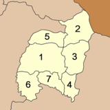
The province is divided into seven districts (amphoe). The districts are further subdivided into 56 communes (tambon) and 653 villages (muban).
Tourism
Sights
Amphoe Hua Taphan
Ban Kham Phra Handicraft Centre (ศูนย์จำหน่ายหัตถกรรมบ้านคำพระ): The centre offers various home made handicrafts made by the women of the area.
Ban Chang Tho Royal Folk Arts and Craft Training Centre (ศูนย์ศิลปาชีพบ้านสร้าง): The centre offers training course on various local crafts such as weaving and gem cutting. The centre here produces world-class gems cutting technicians.
Amphoe Phana
Wat Phra Lao Thep Nimit (วัดพระเหลาเทพนิมิตร): This temple has a Lanna-style chapel which houses the principal Buddha image "Phra Lao Thep Nimit". Built in 1720, the Buddha image, in the form of subduing Mara and decorated with gold leaf, is considered the most beautiful Buddha image of the northeast region. The style mirrors Laotian art from Vientiane which was influenced by Lanna during the 16th-17th centuries.
Don Chao Pu Botanical Park (วนอุทยานดอนเจ้าปู่): The park is home to various wildlife, particularly crab-eating macaques, many of which can be easily spotted. The park houses a sacred shrine as well as a Buddha images showing his birth, enlightenment, the first sermon, and a reclining pose.
Amphoe Senangkhanikhom
Phu Sa Dok Bua (ภูสระดอกบัว): On the mountaintop are 11 stone pools, each a few metres wide. It is quite strange that all of them are occupied by different species of colourful lotus which normally are found only in swampland. Locals insist that no one planted the lotus and that they occur naturally. So, they named these pools "phu sa dok bua", literally "mountain lotus pool". Nearby is a huge cave which can accommodate hundreds of people. It once served as a stronghold of the Communist Party of Thailand.
Amphoe Chanuman
Mekong River scenery (ทิวทัศน์ริมฝั่งโขง): In front of the Amphoe Chanuman office, a long footpath running side by side with the river allows people to enjoy the view. In the dry season, from February to May, water in the Mekong River is much lower and allows islands such as Kaeng Tanglang and Kaeng Hin Khan to surface.
Festivals
The people of Amnat Charoen attach their lifestyle to local traditions and festivals that are held throughout year such as the festival to mark the end of Buddhist Lent, the Rocket Festival, Loy Krathong and Songkran. Moreover, they practice 14 moral regulations such as cleaning feet before entering a home, donating food to monks, avoiding stepping on a monk’s shadow, paying respect to parents, paying homage to Buddha images with flowers, candles, and joss sticks and learning Dhamma every day.
Most people in Amphoe Chanuman are descendants of the Phu Thai ethnic group who migrated from Laos. They specialise in weaving "khit" cloth, preserving its unique patterns. Their traditional musical performance "mor lam" always supports the democratic constitutional monarchy. Amnat Charoen people try to retain the "long khuang" tradition which consisted of teenagers meeting up for communal activities such as weaving or silk spinning accompanied by lively traditional music.
See also
References
- ↑ "Population of the Kingdom" (PDF). Department of Provincial Affairs (DOPA) Thailand (in Thai). 2014-12-31. Retrieved 19 Mar 2015.
- 1 2 "Amnat Charoen". Thailex Travel Encyclopedia. Retrieved 29 January 2016.
External links
 Amnat Charoen travel guide from Wikivoyage
- Province page from the Tourist Authority of Thailand
- Website of the province (Thai only)
 |
Mukdahan Province | Savannakhet Province, |
 | |
| Yasothon Province | |
|||
| ||||
| | ||||
| Ubon Ratchathani Province |
| ||||||||||
| ||||||||||||||||||||||||||||||
Coordinates: 15°54′5″N 104°37′22″E / 15.90139°N 104.62278°E