Álava
| Álava Araba | |||
|---|---|---|---|
| Province | |||
| Historical Territory of Álava1 | |||
| |||
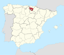
 Location of the Province of Álava within Spain | |||
| Country | Spain | ||
| Autonomous Community | Basque Country | ||
| Capital | Vitoria-Gasteiz | ||
| Government | |||
| • Deputy General | Ramiro González (Basque Nationalist Party) | ||
| Area | |||
| • Total | 2,963 km2 (1,144 sq mi) | ||
| Population (2011) | |||
| • Total | 322,557 | ||
| • Density | 110/km2 (280/sq mi) | ||
| • Ranked | 41 | ||
| • Percent | 0.68% | ||
| Demonym | |||
| Official languages | Spanish, Basque | ||
| Parliament | Cortes Generales | ||
| Congress seats | 4 | ||
| Senate seats | 4 | ||
| Juntas Generales de Álava | 51 | ||
| Website | Diputación Foral de Álava | ||
| |||
Álava (IPA: [ˈalaβa] in Spanish) or Araba (IPA: [aˈɾaba] in Basque), officially Araba/Álava,[1] is a province of Spain and a historical territory of the Basque Country, heir of the ancient Lordship of Álava. Its capital city is Vitoria-Gasteiz which is also the seat of the political main institutions of the autonomous community.[2] It borders the Basque provinces of Biscay and Gipuzkoa to the north, the community of La Rioja to the south, the province of Burgos (in the community of Castile and León) to the west and the community of Navarre to the east. The Enclave of Treviño, surrounded by Alavese territory, is part of the province of Burgos and, so, belongs to the autonomus community of Castile and León, not Álava.
It is the largest of the three provinces in the Basque Autonomous Community in geographical terms, with 2,963 km², but also the least populated with 322,557 inhabitants (2012).
Etymology
Built around the Roman mansion Alba located on the road ab Asturica Burdigalam (possibly the current village of Albeniz near Agurain), it has sometimes been argued the name may stem from that landmark. However, according to the Royal Academy of the Basque Language, the origin may be another: The name is first found on Muslim chronicles of the 8th century referring to the Alavese Plains (Spanish Llanada Alavesa, Basque Arabako Lautada), laua in old Basque (currently lautada) with the Arab article added (al + laua), developing into Spanish Álava and Basque Araba (a typical development of l to r between vowels).
Demography and rural landscape
The province numbers 51 municipalities, a population of 315,525 inhabitants in an area of 3,037 km2 (1,173 sq mi), with an average of 104.50 inhab/km².[3] The vast majority of the population clusters in the capital city of Álava, Vitoria-Gasteiz, which also serves as the capital of the Autonomous Community, but the remainder of the territory is sparsely inhabited with population nuclei distributed into seven counties (cuadrillas): Añana; Ayala; Campezo; Laguardia; Salvatierra; Vitoria-Gasteiz; Zuya.
Physical and human geography
Álava is an inland territory and features a largely transitional climate between the humid, Atlantic neighbouring northern provinces and the dry and warmer lands south of the Ebro River. According to the relief and landscape characteristics, the territory is divided into five main zones:
- The Gorbea Foothills: Green hilly landscape.
- The Valleys: Low valleys, drier, sparsely populated.
- The Plains: Heartland of Álava comprising Vitoria and Salvatierra-Agurain, with a central urban area and crop landscape prevailing around and bounded south and north by the Basque Mountains.
- The Alavese Mountains: Higher forest lands.
- The Alavese Rioja: Oriented to the south on the left bank of the Ebro River, perfect for vineyards.
- Ayala: The area clustering around the Nervión River, with Amurrio and Laudio as its major towns. The region shows close bonds with Bilbao and Biscaye and an industrial landscape.
Unlike Biscay and Gipuzkoa, but for Ayala and Aramaio, the waters of Álava pour into the Ebro and hence to the Mediterranean by means of two main waterways, i.e. the Zadorra (main axis of Álava) and Bayas Rivers. In addition, the Zadorra Reservoir System harvests a big quantity of waters that supply not only the capital city but other major Basque towns and cities too, like (Bilbao, etc.).
While in 1950 agriculture and farming shaped the landscape of the territory (42.4% of the working force vs 30.5% in industry and construction), the trend shifted gradually during the 60s and 70s on the grounds of a growing industrial activity in the Alavese Plains (Llanada Alavesa), with the main focus lying on the industrial estates of Vitoria-Gasteiz (Gamarra, Betoño and Ali Gobeo) and, to a lesser extent, Salvatierra-Agurain and Araia. At the turn of the century, only 2% of the working Alavese people was in agriculture, while a 60% was in the third sector and 32% in manufacturing.[3] Industry associated to iron and metal developed earlier in the Atlantic area much in tune with Bilbao's economic dynamics, with droves of people flocking to and clustering in Amurrio and Laudio, which have since become the third and second main towns of Álava.
Lordship of Álava
List of rulers (modern Spanish names):
- Eylon, up to 866
- Rodrigo c.867–870, count of Castile
- Vela Jiménez 870–c.887
- Munio Velaz c.887–c.921
- Álvaro Herraméliz c.921–931, also count of Cerezo and Lantarón
- Fernán González 931–970, also count of Castile, Álava feudatary of Castile until 1030
- García Fernández 970–995
- Munio González 1030–1043
- Fortunio Íñiguez 1043–1046
- Munio Muñoz (co-lord) 1046–1060, Álava feudatary of Navarre, 1046–1085
- Sancho Maceratiz (co-lord) 1046–1060
- Ramiro 1060–1075
- Marcelo 1075–1085
- Lope Íñiguez 1085–?, Álava feudatary of Castile until 1123
- Lope Díaz the White ?–1093
- Lope González 1093–1099
- Lope Sánchez 1099–1114
- Diego López I 1114–1123
- Ladrón Íñiguez 1123–1158, Álava feudatary of Navarre until 1199
- Vela Ladrón 1158–1175
- Juan Velaz 1175–1181
- Diego López II 1181–1187
- Íñigo de Oriz 1187–1199
- Diego López de Haro I 1199–1214, Álava feudatary of Castile until personal union of 1332
- Lope Diaz de Haro I 1214–1240
- Nuño González de Lara 1240–1252
- Diego López de Haro II 1252–1274
- Fernando de la Cerda 1274–1280
- Lope Díaz II de Haro 1280–1288
- Juan Alonso de Haro 1288–1310
- Diego López de Salcedo 1310–1332
The title is attributed to the Castilian kings after 1332.
Bishopric
The Arab invasion of the Ebro valley in the 8th century, many Christians of the diocese of Calahorra sought refuge in areas further north free of Arab rule. The diocese called Álava or Armentaria arose in the mid-9th century. From then until the 11th century the names of several bishops of this see are known, the best known being Fortún, who in 1072 went to Rome to argue before Pope Alexander II in defence of the Mozarabic Rite, which King Alfonso VI of León and Castile had decreed should be replaced by the Roman Rite. The territory of the diocese of Álava, which corresponded more or less to that of the present diocese of Vitoria, was reabsorbed into that of Calahorra, when King Alfonso conquered La Rioja.[4]
No longer a residential bishopric, Álava is today listed by the Catholic Church as a titular see.[5]
Bishops of Alava
For a list, see Antonio Rivera, ed., Historia de Álava (2003), pp. 599–600.
- Bivere (before 871 – after 876)
- Álvaro (c. 881 – c. 888)
- Munio I (937/956 – 971)
- ? Julián (? – 984)
- Munio II (984 – 989)
- García I (996 – c. 1021)
- Munio III (c. 1024 – c. 1030)
- García II (1037 – 1053/1055)
- Fortún [Fortuño] I (1054/1055)
- Vela (1056 – 1062)
- Munio IV (1062 – c. 1065)
- Fortún II (c. 1067 – 1088)[4]
See also
Footnotes
| Wikimedia Commons has media related to Álava-Araba. |
- ↑ Ley 19/2011, de 5 de julio, por la que pasan a denominarse oficialmente "Araba/Álava", "Gipuzkoa" y "Bizkaia" las demarcaciones provinciales llamadas anteriormente "Álava", "Guipúzcoa" y "Vizcaya"
- ↑ Ley 1/1980 de Sede de las Instituciones de la Comunidad Autónoma del País Vasco
- 1 2 "Su población". Diputación Foral de Álava. Retrieved 2010-05-09. Text in Spanish
- 1 2 España Sagrada, tomo XXXIII, Madrid 1781, pp. 223–271
- ↑ Annuario Pontificio 2013 (Libreria Editrice Vaticana, 2013, ISBN 978-88-209-9070-1), p. 828
| ||||||||||||
Coordinates: 42°50.67′N 2°45.62′W / 42.84450°N 2.76033°W

