Aizumi, Tokushima
| Aizumi 藍住町 | ||
|---|---|---|
| Town | ||
| ||
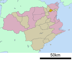
 Location of Aizumi in Tokushima Prefecture | ||
 Aizumi Location in Japan | ||
| Coordinates: 34°8′N 134°30′E / 34.133°N 134.500°ECoordinates: 34°8′N 134°30′E / 34.133°N 134.500°E | ||
| Country | Japan | |
| Region | Shikoku | |
| Prefecture | Tokushima Prefecture | |
| District | Itano | |
| Area | ||
| • Total | 16.27 km2 (6.28 sq mi) | |
| Population (2003) | ||
| • Total | 31,623 | |
| • Density | 1,900/km2 (5,000/sq mi) | |
| Time zone | Japan Standard Time (UTC+9) | |
| Website |
www | |
Aizumi (藍住町 Aizumi-chō) is a town located in Itano District, in northeastern Tokushima Prefecture, Japan.in Tokushima Prefecture Ja.svg
As of 2003, the town has an estimated population of 31,623 and a density of 1,943.64 persons per km². The total area is 16.27 km².
The historical significant site of Shozui castle park can be found in the east of the town. Shozui castle park is the site of the ruins of Shozui castle. This castle was the stronghold from which various historical lords such as Lord Hosokawa and Lord Miyoshi ruled over Awa Province, now known as modern day Tokushima Prefecture, during the Muromachi era (1336 to 1573).
Location
Aizumi is situated on the north side of the downstream area of the Yoshino River, which flows through the middle of Tokushima. The town is located around the middle of Itano district in a delta zone that surrounds the Yoshinogawa and old Yoshinogawa. At 5.17 meters above sea level it is a very flat area with no hilly or mountainous areas found within the confines of the town district.
To the south of the town across the Yoshinogawa lies the town of Tokushima, and in a northwest direction, on the other side of the old Yoshino River, are Itano and Naruto. To the east lies Kitajima.
Climate
The annual mean air temperature is 15.7 degrees; the temperature is at its lowest in January when the average temperature is a comparatively warm 5.2 degrees. The annual mean rainfall is 1,586.6mm, and the average monthly discharge is 132.2mm. During winter, the average monthly discharge is 50mm throughout the season, with a touch of Seto Inland Sea-style climate being present.
History and development
During the Muromachi era (1336 to 1573), the feudal lord that controlled the province of Awa set up his residence and administrative base in Shozui in the 15th century and the area soon became a prominent political and cultural center in Shikoku.
At the end of the Sengoku period (Warring States period), the Hosokawa clan was disposed by Lord Miyoshi whose family controlled the Muromachi Shogunate. Lord Muromachi controlled the region until he was in turn disposed when Chosokabe Motochika from Tosa (Kōchi prefecture) gained control of Awa.
During the 17th century Tokushima city replaced Shozui as the main administrative center of Tokushima and the area declined over the centuries with most of the significant development in the region taking place in Tokushima-city, south of the Yoshinogawa. Thus for a long time Aizumi was a rural, agricultural area with little urban development.
External links
 Media related to Aizumi, Tokushima at Wikimedia Commons
- Aizumi official website (Japanese)
|