Aichi Kōgen Quasi-National Park
| Aichi-Kōgen Quasi-National Park | |
|---|---|
|
愛知高原国定公園 Aichi-Kōgen Kokutei Kōen | |
|
IUCN category III (natural monument or feature) | |
|
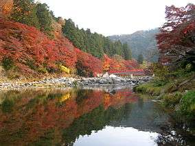
Kourankei, Mt.Iimori, Tomoe river, and Taigetsukyo bridge. | |
 | |
| Location | Honshū, Japan |
| Coordinates | 35°02′02″N 137°24′36″E / 35.034°N 137.41°ECoordinates: 35°02′02″N 137°24′36″E / 35.034°N 137.41°E[1] |
| Area | 21,705 hectares (53,630 acres) |
| Established | December 28, 1970 |
| Governing body | Aichi prefectural government [2] |
Aichi-Kōgen Quasi-National Park (愛知高原国定公園 Aichi-Kōgen Kokutei Kōen) is a 21,705-hectare (53,630-acre) quasi-national park in the Tōkai region of Honshū in Japan. It is rated a protected landscape (category III) according to the IUCN. As with neighboring Hida-Kisogawa Quasi-National Park and Tenryū-Okumikawa Quasi-National Park the park includes mountainous landscapes with gorges and dense forests. The part is on the border between Shizuoka and Aichi Prefecture, but is entirely within Aichi. It also includes a portion of the Tōkai Nature Trail. [3] It encompasses the area around Yahagi Dam and the Kourankei scenic areas. The area was designated a quasi-national park on December 28, 1970.
Like all Quasi-National Parks in Japan, the park is managed by the local prefectural governments.[2]
See also
| Wikimedia Commons has media related to Aichikōgen Quasi-National Park. |
References
- Southerland, Mary and Britton, Dorothy. The National Parks of Japan. Kodansha International (1995). ISBN 4-7700-1971-8
- ↑ Aichi Kogen Quasi National Park protectedplanet.net
- 1 2 "National Park systems: Definition of National Parks". National Parks of Japan. Ministry of the Environment of the Government of Japan. Retrieved 2008-08-29.
- ↑ "List of Quasi-national Parks". Official Home Page of the Ministry of the Environment. Ministry of the Environment Government of Japan. 1994-03-31. Retrieved 2009-07-05.

