Bramsche
| Bramsche | ||
|---|---|---|
| ||
 Bramsche | ||
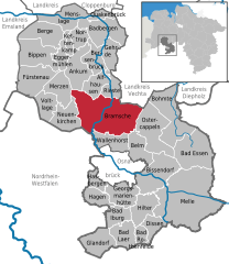
Location of Bramsche within Osnabrück district 
 | ||
| Coordinates: 52°24′N 7°59′E / 52.400°N 7.983°ECoordinates: 52°24′N 7°59′E / 52.400°N 7.983°E | ||
| Country | Germany | |
| State | Lower Saxony | |
| District | Osnabrück | |
| Government | ||
| • Mayor | Heiner Pahlmann (SPD) | |
| Area | ||
| • Total | 183.32 km2 (70.78 sq mi) | |
| Population (2013-12-31)[1] | ||
| • Total | 30,134 | |
| • Density | 160/km2 (430/sq mi) | |
| Time zone | CET/CEST (UTC+1/+2) | |
| Postal codes | 49565 | |
| Dialling codes | 05461 | |
| Vehicle registration | OS | |
| Website | bramsche.de | |
Bramsche is a town in the district of Osnabrück, Lower Saxony, Germany. It is about 20 kilometres (12 miles) north of Osnabrück, at 52°24′N 7°59′E / 52.400°N 7.983°E. Population is 30858 (2002).
In 1971/72 12 previously independent municipalities were included into the town.
- Achmer
- Balkum
- Epe and Malgarten
- Engter
- Evinghausen
- Hesepe
- Kalkriese - site of the Battle of the Teutoburg Forest
- Lappenstuhl
- Pente
- Schleptrup
- Sögeln
- Ueffeln
International relations
Bramsche is twinned with:
References
External links
- http://www.bramsche.de Official homepage
- City Panoramas - Panoramic Views of Bramsche
- http://www.bramsche.nl es war einmal: Die Hollaender
|
This article is issued from Wikipedia - version of the Sunday, May 17, 2015. The text is available under the Creative Commons Attribution/Share Alike but additional terms may apply for the media files.
